
Войти
| Ардмор, Алабама | |
|---|---|
| Город | |
 Вид на проспект Ардмор nue (SR 53 ); Ратуша слева Вид на проспект Ардмор nue (SR 53 ); Ратуша слева | |
 Местоположение Ардмора в округе Лаймстоун, Алабама. Местоположение Ардмора в округе Лаймстоун, Алабама. | |
| Координаты: 34 ° 59′13 ″ с.ш., 86 ° 50′35 ″ з.д. / 34,98694 ° с.ш. 86,84306 ° з. 34.98694; -86.84306 | |
| Страна | США |
| Штат | Алабама |
| Округ | Лаймстоун Каунти, Алабама |
| Инкорпорация | 1922 |
| Правительство | |
| • Мэр | Билли Шеннон |
| Площадь | |
| • Всего | 2,05 кв. Мили (5,31 км) |
| • Земля | 2,04 кв. Мили (5,29 км) |
| • Вода | 0,01 кв. Мили (0,02 км) |
| Высота | 883 футов (269 м) |
| Население (2010 ) | |
| • Всего | 1,194 |
| • Оценка (2019) | 1463 |
| • Плотность | 716,45 / кв. Миля (276,57 / км) |
| Часовой пояс | UTC-6 (Центральный (CST) ) |
| • Лето (DST ) | UTC-5 (CDT) |
| Почтовый индекс | 35739 |
| Код (а) города) | 256 |
| Код FIPS | 01-02260 |
| GNIS идентификатор функции | 0113204 |
| Веб-сайт | www.townofardmorealabama.com |
Ардмор - это город в округе Лаймстоун, Алабама, США, который входит в район метро Хантсвилл-Декатур. Ракета Saturn IB в Центре обслуживания в Алабаме, к югу от границы с Теннесси, на межгосударственной автомагистрали 65. Население города по переписи 2010 года составляет 1194 человека. Он граничит со своим городом-побратимом Ардмор, Теннесси.
поселение первоначально называлось Остин в честь Алекса Остина, который выбрал это место в качестве места для станции вдоль железной дороги Луисвилл и Нэшвилл. Позже железнодорожная компания переименовала город в Ардмор в честь общины Ардмор, штат Пенсильвания. Ардмор, штат Алабама, был включен в 1922 году.
Ардмор расположен в 34 ° 59′13 ″ с.ш., 86 ° 50′36 ″ з.д. / 34,98694 ° с.ш. 86,84333 ° W / 34.98694; -86,84333 (34,987052, -86,843228). Это самый северный населенный пункт в штате Алабама. Город сосредоточен вдоль Маршрута штата Алабама 53, который проходит с юга на север вдоль Ардмор-авеню, прежде чем повернуть на восток вдоль границы штата, где он проходит в соответствии с Маршрутом штата Теннесси 7 на Мейн-стрит.. Автомагистраль между штатами 65, которая соединяет Нэшвилл и Бирмингем, проходит к западу от Ардма. ore.
Main Street is the state line. The road heading northbound/westbound is in Tennessee, while southbound/eastbound is in Alabama.
According to the U.S. Census Bureau, the town has a total area of 2.0 square miles (5.2 km), all land.
| Census | Pop. | %± | |
|---|---|---|---|
| 1930 | 266 | — | |
| 1940 | 381 | 43.2% | |
| 1950 | 408 | 7.1% | |
| 1960 | 439 | 7.6% | |
| 1970 | 761 | 73.3% | |
| 1980 | 1,096 | 44.0% | |
| 1990 | 1,090 | −0.5% | |
| 2000 | 1,034 | −5.1% | |
| 2010 | 1,194 | 15.5% | |
| 2019 (est.) | 1,463 | 22.5% | |
| U.S. Decennial Census | |||
Ardmore first appeared on the 1930 U.S. Census as an incorporated town.
At the 2000 census there were 1,034 people, 460 households, and 276 families in the town. The population density was 506.8 people per square mile (195.7/km). There were 506 housing units at an average density of 248.0 per square mile (95.8/km). The racial makeup of the town was 96.23% White, 0.87% Black or African American, 0.48% Native American, 0.77% Asian, 0.10% Pacific Islander, 1.16% from other races, and 0.39% from two or more races. 1.74%. were Hispanic or Latino of any race.
Of the 460 households 27.0% had children under the age of 18 living with them, 43.0% were married couples living together, 11.5% had a female householder with no husband present, and 39.8% were non-families. 36.5% of households were made up of individuals, and 21.1% were one person aged 65 or older. The average household size was 2.25, and the average family size was 2.96.
The age distribution was 25.0% under the age of 18, 8.3% from 18 to 24, 25.7% from 25 to 44, 24.6% from 45 to 64, and 16.4% 65 or older. The median age was 37 years. For every 100 females, there were 81.4 males. For every 100 females age 18 and over, there were 78.0 males.
The median household income was $28,352 and the median family income was $40,673. Males had a median income of $29,531 versus $19,875 for females. The per capita income for the town was $18,447. About 10.7% of families and 17.9% of the population were below the poverty line, including 20.2% of those under age 18 and 30.7% of those age 65 or over.
At the 2010 census there were 1,194 people, 505 households, and 333 families in the town. The population density was 517 people per square mile (195.1/km). There were 578 housing units at an average density of 289 per square mile (109.1/km). The racial makeup of the town was 94.3% White, 1.9% Black or African American, 0.8% Native American, 0.9% Asian, 0.1% Pacific Islander,.6% from other races, and 1.4% from two or more races. 1.3%. were Hispanic or Latino of any race.
Of the 505 households 28.1% had children under the age of 18 living with them, 44.8% were married couples living together, 15.4% had a female householder with no husband present, and 34.1% were non-families. 31.5% of households were made up of individuals, and 18.5% were one person aged 65 or older. The average household size was 2.36, and the average family size was 2.97.
The age distribution was 24.9% under the age of 18, 10.7% from 18 to 24, 25.7% from 25 to 44, 21.9% from 45 to 64, and 16.8% 65 or older. The median age was 37.1 years. For every 100 females, there were 82.3 males. For every 100 females age 18 and over, there were 90.7 males.
The median household income was $32,196 and the median family income was $36,779. Males had a median income of $31,600 versus $37,841 for females. The per capita income for the town was $18,931. About 13.0% of families and 18.8% of the population were below the poverty line, including 21.9% of those under age 18 and 19.2% of those age 65 or over.
| Census. Year | Population. Racial. Majority | State. Place. Rank | County. Place. Rank | White. (White, Non-. Hispanic 1980- | Black | Hispanic. (1980- | Native. American | Asian | Pacific. Islander. (1980- | Other | 2 or More. Races. (2000- |
|---|---|---|---|---|---|---|---|---|---|---|---|
| 1930 | 266 (-) | 248th(-) | 2nd(-) | ||||||||
| 1940 | 381 ↑ | 219th↑ | 2ndX | ||||||||
| 1950 | 408 ↑ | 260th↓ | 2ndX | ||||||||
| 1960 | 439 ↑ | 259th↑ | 2ndX | ||||||||
| 1970 | 761 ↑ | 238th↑ | 2ndX | ||||||||
| 1980 | 1,096 ↑ | 238thX | 2ndX | 1,073 ↑ 97.9% | 8 (-) 0.7% | 10 (-) 0.9% | 2 (-) 0.2% | 2 (-) 0.2% | 1 (-) 0.1% | ||
| 1990 | 1,090 ↓ | 250th↓ | 2ndX | 1,065 ↓ 97.7% | 18 ↑ 1.7% | 6 ↓ 0.6% | 1 ↓ 0.1% | ||||
| 2000 | 1,034 ↓ | 277th↓ | 2ndX | 988 ↓ 95.6% | 9 ↓ 0.9% | 18↑ 1.7% | 5 ↑ 0.5% | 8 (-) 0.8% | 1(-) 0.1% | 12(-) 1.2% | 4 (-) 0.4% |
| 2010 | 1,194↑ | 282nd↓ | 4th↓ | 1,119↑ 93.7% | 23↑ 1.9% | 16 ↓ 1.3% | 9↑ 0.8% | 11↑ 0.9% | 1X 0.1% | 7 ↓ 0.6% | 17↑ 1.4% |
Ardmore is the setting of a song by Old Crow Medicine Show called "Alabama High-Test," on the album Tennessee Pusher.

Ardmore Road Signs at state line
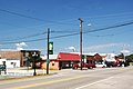
Downtown Ardmore, AL
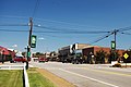
Downtown Ardmore, AL

Ardmore Town Hall

Ardmore Airport

Saturn 1B Rocket at AL Welcome Center, Ardmore

Saturn 1B Rocket at AL Welcome Center, Ardmore

Saturn 1B Rocket at AL Welcome Center, Ardmore
Coordinates : 34°59′13″N 86°50′36″W / 34.987052°N 86.843228°W / 34.987052; -86.843228