
Sinda Island
| Sinda Island | |
|---|---|
 Shore of Sinda Island | |
 location in Tanzania | |
| Location | Dar es Salaam Region, Kigamboni District |
| Nearest city | Dar es Salaam |
| Coordinates | 6°49′13″S 39°23′52″E / 6.82028°S 39.39778°E |
| Area | 4.6km² |
| Established | March 2007 |
| Governing body | Marine Parks & Reserves Authority (Tanzania) |
| Website | DMRS |
Sinda Island (Kisiwa cha Sinda, in Swahili) is a protected, uninhabited island in the Sea of Zanj under the Dar es Salaam Marine Reserve (DMRS) with the IUCN category II located within Kigamboni District of Dar es Salaam Region in Tanzania. The islands reserve measures around 4.6km2 consisting of inner and outer Sinder Island. South of the island is Kikwero reef and west is the Somangila ward of Kigamboni.[1][2][3] The island is home to endangered coconunt crabs. [4] The Islands are home to ruins that date back to the 19th century, but Arab sailor Ibn Majid first noted the islands in 1470. [5]
Sinda Island Gallery
-
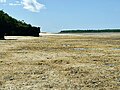 Outer Sinda Island during low tide.
 -
 Virgin coastal Forest of Sinda Island.
 -
 Neglected recreation area on Sinda Iasland.
 -
 19-20th Century ruins on the island.
 -
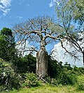 The great bottle Baobab of Sinda.
 -
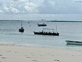 View of Ilala MC from Sinda Island


See also[edit]
References[edit]
- ^ "Marine Parks and Marine Reserves of Tanzania". Retrieved 2020-09-07.
- ^ Levine, Arielle. (2010). Local Responses to Marine Conservation in Zanzibar, Tanzania. Journal of International Wildlife Law and Policy. July–December 2004. 183-202. 10.1080/13880290490883241
- ^ Okera, W. "The zooplankton of the inshore waters of Dar es Salaam (Tanzania, SE Africa) with observations on reactions to artificial light." Marine Biology 26 (1974): 13-25.
- ^ Caro, Tim, et al. "A case study of the coconut crab Birgus latro on Zanzibar highlights global threats and conservation solutions." Oryx 55.4 (2021): 556-563.
- ^ "Sinda Island history". Retrieved 21 October 2023.
| Categories | |
|---|---|
| Districts | |
| History | |
| Education | |
| Transport | |
| Landmarks | |
| National Parks | |
This Dar es Salaam Region location article is a stub. You can help Wikipedia by expanding it. |