
Saint-Léon-sur-Vézère
Saint-Léon-sur-Vézère | |
|---|---|
 The high street in Saint-Léon-sur-Vézère | |
 Coat of arms | |
Location of Saint-Léon-sur-Vézère  | |
 Saint-Léon-sur-Vézère  Saint-Léon-sur-Vézère | |
| Coordinates: 45°00′41″N 1°05′22″E / 45.0114°N 1.0894°E | |
| Country | France |
| Region | Nouvelle-Aquitaine |
| Department | Dordogne |
| Arrondissement | Sarlat-la-Canéda |
| Canton | Vallée de l'Homme |
| Government | |
| • Mayor (2020–2026) | Yannick Dalbavie[1] |
| Area 1 | 13.76 km2 (5.31 sq mi) |
| Population (2021)[2] | 426 |
| • Density | 31/km2 (80/sq mi) |
| Time zone | UTC+01:00 (CET) |
| • Summer (DST) | UTC+02:00 (CEST) |
| INSEE/Postal code | 24443 /24290 |
| Elevation | 62–260 m (203–853 ft) (avg. 70 m or 230 ft) |
| 1 French Land Register data, which excludes lakes, ponds, glaciers > 1 km2 (0.386 sq mi or 247 acres) and river estuaries. | |
Saint-Léon-sur-Vézère (French pronunciation: [sɛ̃ leɔ̃ syʁ vezɛʁ], literally Saint-Léon on Vézère; Occitan: Sent Leu de Vesera) is a commune in the Dordogne department in Nouvelle-Aquitaine in southwestern France.
Population[edit]
| Year | Pop. | ±% |
|---|---|---|
| 1962 | 319 | — |
| 1968 | 345 | +8.2% |
| 1975 | 334 | −3.2% |
| 1982 | 390 | +16.8% |
| 1990 | 427 | +9.5% |
| 1999 | 419 | −1.9% |
| 2008 | 433 | +3.3% |
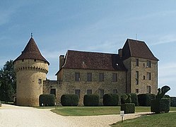
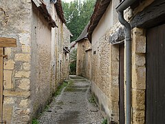
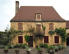
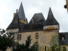
Views[edit]
- Views of Saint-Léon-sur-Vézère
-
-
-
-

-


.JPG)
.JPG)
See also[edit]
References[edit]
- ^ "Répertoire national des élus: les maires". data.gouv.fr, Plateforme ouverte des données publiques françaises (in French). 9 August 2021.
- ^ "Populations légales 2021". The National Institute of Statistics and Economic Studies. 28 December 2023.
Wikimedia Commons has media related to Saint-Léon-sur-Vézère.
| International | |
|---|---|
| National | |
This Dordogne geographical article is a stub. You can help Wikipedia by expanding it. |