Tut District
Tut District | |
|---|---|
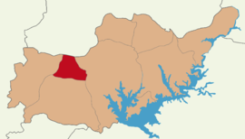
 Map showing Tut District in Adıyaman Province | |
| Coordinates: 37°48′N 37°55′E / 37.800°N 37.917°E | |
| Country | Turkey |
| Province | Adıyaman |
| Seat | Tut |
| Government | |
| • Kaymakam | Yunus Kızılgüneş |
| Area | 290 km2 (110 sq mi) |
| Population (2021) | 9,686 |
| • Density | 33/km2 (87/sq mi) |
| Time zone | UTC+3 (TRT) |
| Website | www |
Tut District is a district of Adıyaman Province of Turkey. Its seat is the town Tut.[1] Its area is 290 km2,[2] and its population is 9,686 (2021).[3] The Kaymakam is Yunus Kızılgüneş.[4]
The district was established in 1990.[5]
Composition[edit]
There is 1 municipality in Tut District:[1]
There are 14 villages in Tut District:[6]
References[edit]
- ^ a b İlçe Belediyesi, Turkey Civil Administration Departments Inventory. Retrieved 22 December 2022.
- ^ "İl ve İlçe Yüz ölçümleri". General Directorate of Mapping. Retrieved 18 December 2022.
- ^ "Address-based population registration system (ADNKS) results dated 31 December 2021" (XLS) (in Turkish). TÜİK. Retrieved 22 December 2022.
- ^ "Tut Kaymakamlığı". www.tut.gov.tr. Retrieved 2019-12-18.
- ^ "İl İdaresi ve Mülki Bölümler Şube Müdürlüğü İstatistikleri - İl ve İlçe Kuruluş Tarihleri" (PDF) (in Turkish). p. 3. Retrieved 27 December 2022.
- ^ Köy, Turkey Civil Administration Departments Inventory. Retrieved 22 December 2022.


