Te Waihorotiu railway station
Te Waihorotiu | |
|---|---|
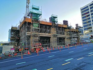
 The south tower of Te Waihorotiu railway station under construction | |
| General information | |
| Location | Auckland New Zealand |
| Coordinates | 36°50′58.81″S 174°45′48.56″E / 36.8496694°S 174.7634889°E |
| Owned by | Auckland Transport |
| Operated by | Auckland One Rail |
| Line(s) | City Rail Link |
| Platforms | 2 |
| Tracks | 2 |
| Construction | |
| Structure type | Underground |
| Accessible | Yes |
| Other information | |
| Website | City Rail Link |
| History | |
| Opened | 2025 (planned) |
| Electrified | Yes (from opening) |
| Location | |
 | |
Te Waihorotiu railway station, also known as Aotea railway station, is an under construction underground railway station in Auckland, New Zealand. It is due to open in late 2025 as part of the City Rail Link project.[1] It is expected to become the busiest rail station in New Zealand when opened, and will serve the Aotea Centre, Auckland Town Hall and Skycity Auckland.[2]
Layout[edit]
Te Waihorotiu station will be located 15 metres underground, built between Albert Street, Wellesley Street, Victoria Street and Bledisloe Lane.[3] Construction commenced in September 2019.[4][5]
Construction gallery[edit]
-
Te Waihorotiu railway station trench seen from Albert Street
-
Te Waihorotiu railway station trench seen from Wellesley Street
References[edit]
- ^ "City Rail Link deadline not guaranteed - project boss". Radio New Zealand. 4 December 2023. Retrieved 4 December 2023.
- ^ Stations - Aotea City Rail Link
- ^ Take a walk: Aotea Station, City Rail Link New Zealand Herald 3 September 2018
- ^ Aotea Station work starts City Rail Link 9 September 2019
- ^ NZ City Rail Link commences next stage of construction Rail Express 6 February 2020


