
Talk:Ilagan
| This article is rated Start-class on Wikipedia's content assessment scale. It is of interest to the following WikiProjects: | |||||||||||||||||||||
| |||||||||||||||||||||


Daily pageviews of this article
A graph should have been displayed here but graphs are temporarily disabled. Until they are enabled again, visit the interactive graph at pageviews.wmcloud.org |
A move query[edit]
Will it be possible for this municipality to re-convert back to "Component City" status? Because at least a city in the Philippines should have a population of at least between 20,000 and 80,000 people. jlog3000 (talk) 14:38, 26 March 2008 (UTC)
- It is already converted following the plebiscite on August 11, 2012 when residents favor Ilagan city-hood. OK(talk) 13:50, 3 September, 2012 (UTC+800) —Preceding undated comment added 05:41, 3 September 2012 (UTC)
Move?[edit]
- The following discussion is an archived discussion of a requested move. Please do not modify it. Subsequent comments should be made in a new section on the talk page. No further edits should be made to this section.
The result of the move request was: moved to Ilagan. Jenks24 (talk) 12:16, 24 June 2012 (UTC)
Ilagan City, Isabela → ? –
- <Cityname>
<City>rule applies to all Philippine city articles, both old and new.- Part of series of multiple page move requests involving Philippine cities under the category General rule -> eliminate the word “city” from the name of the Philippine cities except those needing disambiguation. This request is made after preliminary discussions for the removal of the word "city" from most of the article titles of Philippine cities and providing disambiguation wherever necessary. Some disambiguation may involve using the <cityname>, <provincename> format, regardless if it is highly urbanized, independent or component cities. In here, <provincename> purports to describe the general area and not necessary as the mother political unit of the city, since some people might have wrongly believed that this naming convention is exclusively for Philippine towns only. For more information please see Wikipedia_talk:Tambayan_Philippines/Task_force_LGU#Article_names_for_Philippine_cities:_.3Ccityname.3E_.3Ccity.3E. --RioHondo (talk) 07:58, 17 June 2012 (UTC)
- Move to either Ilagan or Ilagan, Isabela. At least it is not the Perth, Western Australia situation, right? If there are no other cities or any other area with the same name, then a name change can do. --George Ho (talk) 10:56, 17 June 2012 (UTC)
- Ilagan City, Isabela → Ilagan. As per WP:MOSPHIL, city names need not be disambiguated when there are no other places with the same name. -- RioHondo (talk) 16:32, 17 June 2012 (UTC)
- Move to Ilagan per WP:MOSPHIL --JinJian (talk) 20:48, 17 June 2012 (UTC)
- The above discussion is preserved as an archive of a requested move. Please do not modify it. Subsequent comments should be made in a new section on this talk page. No further edits should be made to this section.
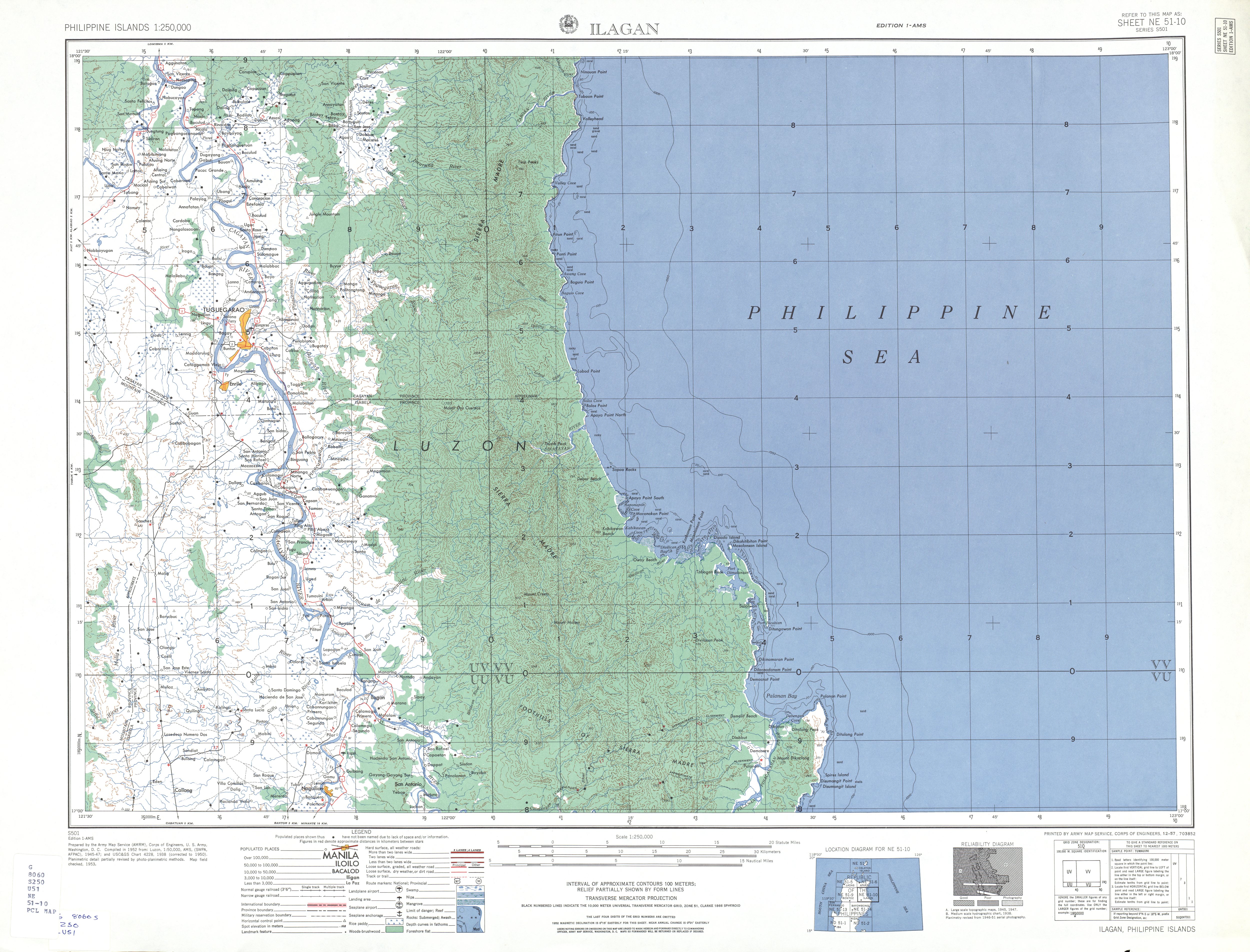
Map[edit]
Anyone who know what baranggay of Ilagan is the one facing the Pacific Ocean? According to the map, Ilagan City extends to the coastal area, but i do believe it does not extend to the ocean because that is already a part of Divilacan. Thanks for your help. jmarkfrancia (talk) 15:58, 27 August 2012 (UTC)
- I'm not sure which Ilagan barangay is located on the Pacific coast, but I do know Ilagan extends to both Divilacan and the Pacific Ocean on the northeast. From Republic Act No. 8474 (Charter of the City of Ilagan), "The City of Ilagan shall comprise the present territory of the Municipality of Ilagan over which it has jurisdiction bounded on the north by the Municipality of Tumauini; on the west, by the Municipality of Quirino; on the northeast, by the Municipality of Divilican and the Pacific Ocean; and on the southeast, by the Municipality of San Mariano." Btw, Fuyot Springs National Park, located in the Ilagan portion of the Sierra Madre range close to the Pacific coast, is at Barangay Santa Victoria, the easternmost barangay that I know. Cheers! RioHondo (talk) 04:45, 3 September 2012 (UTC)
- With information provided by RA8494, Ilagan map therefore is not redrawn (talk) 13:46, 3 September, 2012 (UTC+800)
Map of Ilagan is re-drawn. (talk) 18:16, 30 August, 2012 (UTC+800) — Preceding unsigned comment added by 112.202.177.251 (talk) 10:16, 30 August 2012 (UTC)
- I searched the map and Fuyot Springs is way far to the Pacific Ocean. Ive been searching for the Republic Act 10169, signed by President Benigno Aquino. Im sure, the boundaries of the city are indicated there. jmarkfrancia (talk) 13:40, 3 September 2012 (UTC)
- Indeed. Fuyot Springs in Santa Victoria is just midway between Ilagan and the Pacific. However, House Bill No. 5917 authored by Rep. Rodolfo B. Albano (1st District, Isabela) signed into law as Republic Act No. 10169 by Pres. Aquino on June 21, 2012 does not mention any specific boundaries compared to the 1998 RA 8474. It only states that "The Municipality of Ilagan shall be converted into a component city to be known as the City of Ilagan, hereinafter referred to as the City, which shall comprise the present territory of the Municipality of Ilagan, Province of Isabela. The territorial jurisdiction of the City shall be within the present metes and bounds of the Municipality of Ilagan." --RioHondo (talk) 15:23, 3 September 2012 (UTC)
- There is another law that describes Ilagan's location, this time vis-a-vis the Northern Sierra Madre Natural Park: Republic Act No. 9125 or the Northern Sierra Madre Natural Park (NSMNP) Act of 2001. This act 'contradicts' R.A. 8474 by stating that Ilagan, along with San Mariano, Tumauini, Cabagan and San Pablo form its western limits, while Maconacon, Divilacan, Palanan and Dinapigue are its only coastal or eastern municipalities. I also tried to identify the locations covered by the wiki location map for Ilagan along with its google map counterpart and came to the following discoveries: 1) That the Aubarede Peninsula or Aubarede Point jutting out in the Pacific is actually part of Barangay Bicobian of Divilacan where Port Bicobian is also situated; and 2) That Estagno Island supposedly part of Ilagan and found just north of the Aubarede Point actually belongs to Barangay Dimasalansan again of Divilacan. I also discovered that at present, there are no existing roads that link the Pacific coast to Ilagan until the Ilagan – Divilacan road is completed, and it starts from the mountain village of Sindon Bayabo (possibly Ilagan's easternmost barangay in the Northern Sierra Madre Natural Park along with Villa Imelda [where the Abuan Hydroplant is located], Paliueg and Sindon Maride.) This means that the Ilagan map may not be accurate afterall, and that the veracity of RA 8474 could be dubious and should be re-investigated. --RioHondo (talk) 16:19, 3 September 2012 (UTC)
- I found a more reliable map of Ilagan showing its boundary with Divilacan here. Figure 1-2 of this Abuan Watershed Report prepared by World Wide Fund for Nature(WWF)-Philippines shows the location of the 637.9 sq. km. Abuan River Basin within the Ilagan portion of the Northern Sierra Madre Natural Park that serves as the border between Ilagan and Divilacan. WWF-Philippines heads the Ilagan Watershed Conservation Project in partnership with the local government of Ilagan and Coca-Cola. It also helps to promote the Abuan River as an ecotourism destination and organizes whitewater rafting activities in this area. According to this and other reports from WWF, the Abuan Watershed extends to some 5 barangays in Ilagan, namely: Rang-ayan (Bintacan), Villa Imelda, Cabeseria 27 (Abuan), Cabeseria 10 (Lupigui) and Cabeseria 22 (Sablang). Immediately south of the watershed lies Barangay Sindon where the Ilagan road ends. Table 2-2 of the same report also identifies Mount Cresta as a geologic formation within the watershed area, however Divilacan Peak located further east as seen on this map is not included. Therefore, the maps floating around here in WP and other sites such as google maps are highly inaccurate and must be redrawn. Ilagan does not have a coastline. Aubarede Point, Estagno Island, Salolwan Spring, Dimapnat (Demacnat Point) and Port Bicobian do not belong to Ilagan but to the coastal municipality of Divilacan as also evidenced in their tourism website. The 3D map found in the Isabela website is correct afterall. Cheers! --RioHondo (talk) 16:46, 4 September 2012 (UTC)
- thank you so much! Been searching for proofs for almost a month now, that Ilagan doesnt have a coastline. jmarkfrancia (talk) 13:38, 5 September 2012 (UTC)
- We can't blame our WP contributors. For all we know, they only patterned the map from the ones available like google maps and then it just spread like wildfire. RA 8474 however, was a law that was rejected in 1998 during the first Ilagan cityhood plebiscite so that could no longer be binding. RA 9125 on the other hand, still is. We are then left with these references and the official map found in the official provincial website of Isabela to tell us that the province indeed only has 4 coastal municipalities and that Ilagan is not one of them. We need to get this map replaced now. --RioHondo (talk) 04:10, 6 September 2012 (UTC)
- I am interested with the metrics, sources and evidences used by Wikipedia which came up with the map of Ilagan showing its coastline. This is in consideration for the other side of the fence. --User:Gerryyabes (talk) 08:30, 7 September 2012 (UTC+8)
- Here's more evidence that Ilagan does not have a coastline:
- 1. In the paper entitled "Community-based fisheries management within the Northern Sierra Madre Natural Park, Isabela, Philippines" by A. Aranda da Silva, University of Southampton. -- Figure 1 shows the location of Isabela municipalities within the Northern Sierra Madre Natural Park including their boundaries. This map is consistent with the 3D map found in the official Isabela website.
- 2. In the book, "The Agta of the Northern Sierra Madre. Livelihood strategies and resilience among Philippine hunters-gatherers" by Tessa Minter, Leiden University. -- Map 2.2 on page 46-47 "Distribution of Agta settlements in and around the NSMNP (2000-2005)", the coastal barangays are identified including a Divilacan-Palanan boundary between barangays Dimapnat (Divilacan) and Culasi (Palanan).
- 3. In the book, "Comanagement in Practice: The Challenges and Complexities of Implementation in the Northern Sierra Madre Mountain Region by Denyse J. Snelder, Eileen C. Bernardo, Ateneo de Manila University Press. -- Map 9.1 on page 228, "Agta groups in the Northern Sierra Madre Natural Park", a Divilacan-Palanan boundary is shown again with clear lines separating the coastal municipalities.--RioHondo (talk) 00:40, 8 September 2012 (UTC)
- Here's more evidence that Ilagan does not have a coastline:
- I am interested with the metrics, sources and evidences used by Wikipedia which came up with the map of Ilagan showing its coastline. This is in consideration for the other side of the fence. --User:Gerryyabes (talk) 08:30, 7 September 2012 (UTC+8)
- I can't see Map 9.1 of page 228 of Source #3, likewise with Source #2. jmarkfrancia (talk) 14:47, 11 September 2012 (UTC)
- Have you tried the search function on the left panel or CTRL+F? The maps on those links work for me though. See if you can load the coverage area map of ISELCO II from ERC found here. The map says the same thing. You can also check out the Cagayan Valley Regional Development Plan 2011-2016 where you have Figure 8.1 Flood and Landslide Susceptibility Map of Region 2 that confirms the 3d map's accuracy. Now you have both the provincial and regional governments that say Ilagan has no coastline. --RioHondo (talk) 10:23, 12 September 2012 (UTC)
- Thanks for this! The NEDA's map is the most convincing! jmarkfrancia (talk) 15:25, 13 September 2012 (UTC)
- i already tapped someone who will redraw all the maps related to Isabela, but they are still deliberating on all the evidences we presented. Thanks again. jmarkfrancia (talk) 13:04, 15 September 2012 (UTC)
It is not necessary to mention the cities of Davao and Puerto Princesa. This is not a contest as A is the larger than B and B is larger than C. (talk) 16:10, 01 September, 2012 (UTC+800) — Preceding unsigned comment added by 112.202.166.255 (talk) 08:01, 1 September 2012 (UTC)
Place Of Birth[edit]
Those who are born from August 11, 2012 on-wards will have their Certificate of Live Birth inscripted as City of Ilagan or Ilagan City in their POB (Place of Birth). Prior to August 11, remains as Ilagan, Isabela. For example, if you are born on November 27, 1950 your POB remains as Ilagan, Isabela and not as Ilagan City, Isabela. Gher (talk) 17:50, 02 September, 2012 (UTC+800) — Preceding unsigned comment added by 112.202.170.33 (talk) 09:42, 2 September 2012 (UTC)
92 more barangays[edit]
Naguilian-Baculud is not yet included in the list of Barangays of Ilagan, therefore the city has 92. Gher (talk) 10:05, 18 September, 2012 (UTC+800) —Preceding undated comment added 01:53, 18 September 2012 (UTC)
-Any source of information about the land area per barangay? — Preceding unsigned comment added by Gerryyabes (talk • contribs) 07:07, 18 June 2013 (UTC)
External links modified[edit]
Hello fellow Wikipedians,
I have just modified 4 external links on Ilagan. Please take a moment to review my edit. If you have any questions, or need the bot to ignore the links, or the page altogether, please visit this simple FaQ for additional information. I made the following changes:
- Corrected formatting/usage for http://www.competitive.org.ph/cmcindex/pages/province/?province=Isabela
- Corrected formatting/usage for https://psa.gov.ph/content/psa-releases-2012-municipal-and-city-level-poverty-estimates
- Added archive https://web.archive.org/web/20111216150453/http://www.dotregion2.com.ph/d2/index.php?option=com_content&view=article&id=66&Itemid=78 to http://www.dotregion2.com.ph/d2/index.php?option=com_content&view=article&id=66&Itemid=78
- Added archive https://web.archive.org/web/20131114215939/http://www.census.gov.ph/sites/default/files/attachments/hsd/pressrelease/Cagayan%20Valley.pdf to http://www.census.gov.ph/sites/default/files/attachments/hsd/pressrelease/Cagayan%20Valley.pdf
When you have finished reviewing my changes, you may follow the instructions on the template below to fix any issues with the URLs.
This message was posted before February 2018. After February 2018, "External links modified" talk page sections are no longer generated or monitored by InternetArchiveBot. No special action is required regarding these talk page notices, other than regular verification using the archive tool instructions below. Editors have permission to delete these "External links modified" talk page sections if they want to de-clutter talk pages, but see the RfC before doing mass systematic removals. This message is updated dynamically through the template {{source check}} (last update: 18 January 2022).
- If you have discovered URLs which were erroneously considered dead by the bot, you can report them with this tool.
- If you found an error with any archives or the URLs themselves, you can fix them with this tool.
Cheers.—InternetArchiveBot (Report bug) 08:31, 9 April 2017 (UTC)
External links modified[edit]
Hello fellow Wikipedians,
I have just modified 3 external links on Ilagan. Please take a moment to review my edit. If you have any questions, or need the bot to ignore the links, or the page altogether, please visit this simple FaQ for additional information. I made the following changes:
- Added archive https://web.archive.org/web/20132114534700/http://www.mb.com.ph/articles/368552/ilagan-kicks-off-cityhood-bid to http://www.mb.com.ph/articles/368552/ilagan-kicks-off-cityhood-bid
- Added archive https://web.archive.org/web/20131101010612/http://r02.pia.gov.ph/index.php?article=481358991037 to http://r02.pia.gov.ph/index.php?article=481358991037
- Added archive https://web.archive.org/web/20150630234413/http://news.pia.gov.ph/article/view/481433287402/p7-b-solar-power-plant-to-rise-in-isabela to http://news.pia.gov.ph/article/view/481433287402/p7-b-solar-power-plant-to-rise-in-isabela
When you have finished reviewing my changes, you may follow the instructions on the template below to fix any issues with the URLs.
This message was posted before February 2018. After February 2018, "External links modified" talk page sections are no longer generated or monitored by InternetArchiveBot. No special action is required regarding these talk page notices, other than regular verification using the archive tool instructions below. Editors have permission to delete these "External links modified" talk page sections if they want to de-clutter talk pages, but see the RfC before doing mass systematic removals. This message is updated dynamically through the template {{source check}} (last update: 18 January 2022).
- If you have discovered URLs which were erroneously considered dead by the bot, you can report them with this tool.
- If you found an error with any archives or the URLs themselves, you can fix them with this tool.
Cheers.—InternetArchiveBot (Report bug) 21:57, 11 November 2017 (UTC)
Updates: September 2021[edit]
I have modified the article Ilagan and improved some of the writings and added content as well. If you have any questions,feel free to contact me. (talk to Gerryyabes) 02:30, 04 September, 2021 (UTC+800)
91 barangays of Ilagan[edit]
The list below will be updated here to reflect the most recent census, economic status and barangay election.
| Barangay | Population (2020)[1] |
Economic Class[1] |
Land Area (km2)[2] |
Punong Barangay (Term since 2013)[3] |
|---|---|---|---|---|
| Aggasian | 4,032 | Rural | 264 | Noli B. Bolar |
| Alibagu | 7,916 | Urban | 7,214 | Alfred J. Alluad |
| Alinguigan 1st | 1,909 | Rural | 459 | Elpidio N. Manaligod |
| Alinguigan 2nd | 3,074 | Rural | 7,015 | Antonio B. Gangan |
| Alinguigan 3rd | 1,352 | Rural | 1,765 | Felipe B. Manaligod |
| Arusip | 901 | Rural | 209 | Fernando F. Domingo |
| Baculud | 4,266 | Rural | 3,214 | Remigio D. Balisi |
| Bagong Silang | 676 | Rural | 258 | Herson W. Tolentino |
| Bagumbayan | 2,321 | Urban | 4,317 | Danilo M. Toribio |
| Baligatan | 2,714 | Urban | 6,815 | Roger B. Ramos |
| Ballacong | 824 | Rural | 135 | Roberto S. Bernardo |
| Bangag | 1,307 | Rural | 112 | Sofronio F. Laggui |
| Batong-Labang | 2,348 | Rural | 135 | Florante E. Baysa |
| Bigao | 1,697 | Rural | 225 | Daniel V. Cristobal |
| Cabannungan 1st | 956 | Rural | 715 | Joefry M. Tabug |
| Cabannungan 2nd | 1,852 | Rural | 715 | Joey L. Ramos |
| Cabeseria 2 (Dappat) | 1,198 | Rural | 135 | Reynaldo C. Edrada |
| Cabeseria 3 (San Fernando) | 946 | Rural | 135 | Leandro P. Castillo |
| Cabeseria 4 (San Manuel) | 697 | Rural | 135 | Joseph A. Mata |
| Cabeseria 5 (Baribad) | 882 | Rural | 135 | Precila M. Domingo |
| Cabeseria 6 & 24 (Villa Marcos) | 1,181 | Rural | 135 | Virgilio R. Aunzo |
| Cabeseria 7 (Nangalisan) | 863 | Rural | 215 | Eligio B. Salvador |
| Cabeseria 8 (Santa Maria) | 1,208 | Rural | 135 | Felix P. Maltu |
| Cabeseria 9 & 11 (Capogotan) | 1,695 | Rural | 235 | Tito B. Curampez |
| Cabeseria 10 (Lupigui) | 2,319 | Rural | 235 | Charlito C. Servilla |
| Cabeseria 14 & 16 (Casilagan) | 2,606 | Rural | 182 | Franklin G. Cortez |
| Cabeseria 17 & 21 (San Rafael) | 1,401 | Rural | 235 | Robinson V. Ilayat |
| Cabeseria 19 (Villa Suerte) | 906 | Rural | 135 | Maximiano N. Benedicto |
| Cabeseria 22 (Sablang) | 1,019 | Rural | 225 | Bernard G. Villanueva |
| Cabeseria 23 (San Francisco) | 956 | Rural | 135 | Antony F. Bernabe |
| Cabeseria 25 (Santa Lucia) | 1,121 | Rural | 112 | Marcos J. Agcaoili |
| Cabeseria 27 (Abuan) | 1,011 | Rural | 165 | Domingo B. Quitola |
| Cadu | 662 | Rural | 112 | Leopoldo A. Ancheta |
| Calamagui 1st | 3,918 | Urban | 290 | Hilario Edmund V. Birung |
| Calamagui 2nd | 2,697 | Urban | 5,315 | Alex F. Agor |
| Carikkikan Norte | 544 | Rural | 235 | Eduardo B. Borillo |
| Carikkikan Sur | 208 | Rural | 235 | Arnold G. Apalla |
| Camunatan | 941 | Rural | 9,415 | Samuel G. Mamuri |
| Capellan | 3,098 | Rural | 210 | Edilberto G. Delos Santos |
| Capo | 1,106 | Rural | 235 | Carlito E. Esteban |
| Centro-San Antonio | 4,631 | Rural | 290 | Dante D. Cayapan |
| Centro Poblacion | 568 | Rural | 8,315 | Eufacio Paguirigan |
| Fugu | 1,898 | Rural | 245 | Rosemarie G. Apolonio |
| Fuyo | 977 | Rural | 825 | Santos C. Cabanilla III |
| Gayong-gayong Norte | 815 | Rural | 245 | Francisco R. Cristobal |
| Gayong-gayong Sur | 1,256 | Rural | 245 | Danilo R. Macugay |
| Guinatan | 1,703 | Urban | 9,015 | Mario Bong T. Cabildo |
| Imelda Bliss Village | 7,951 | Urban | 815 | Cecilio G. Jacinto |
| Lullutan | 2,197 | Rural | 715 | Esmeraldo M. Malana |
| Malalam | 1,743 | Rural | 11,015 | Melchor B. Asuncion |
| Malasin (Angeles) | 1,307 | Rural | 112 | Francisco R. Justo |
| Manaring | 2,634 | Rural | 5,815 | Bernardo C. Bulauan |
| Mangcuram | 1,011 | Rural | 1,215 | Edwin R. Lodivico |
| Marana I | 1,746 | Urban | 9,515 | Gregorio S. Ballesteros |
| Marana II | 594 | Rural | 2,230 | Juanito A. Prudencio |
| Marana III | 693 | Rural | 10,215 | Rowena M. Gomez |
| Minabang | 1,678 | Rural | 215 | Jaime T. Santos |
| Morado | 1,073 | Rural | 225 | Teresa A. Gangan |
| Naguilian Norte | 3,233 | Rural | 765 | Francisco A. Cascue |
| Naguilian Sur | 1,304 | Rural | 765 | Ferdinand C. Salvador |
| Namnama | 1,209 | Rural | 235 | Roldan P. Simon |
| Nanaguan | 615 | Rural | 235 | Milagros T. Fabros |
| Osmeña (Sinippil) | 3,225 | Urban | 7,815 | June T. Yadao |
| Paliueg | 1,545 | Rural | 135 | Nelson B. Layugan |
| Pasa | 1,113 | Rural | 125 | Rogelio G. Aquino |
| Pilar | 939 | Rural | 125 | Ferdinand T. Tabliago |
| Quimalabasa | 349 | Rural | 215 | Rogelio S. Agamata |
| Rang-ayan (Bintacan) | 1,658 | Rural | 235 | Juanito V. Gonzales |
| Rugao | 1,245 | Rural | 11,315 | Diosdado M. Bermudez |
| Salindingan | 1,368 | Rural | 175 | Danny T. Adorable |
| San Andres (Angarilla) | 1,083 | Rural | 1,862 | Venturito C. Marayag |
| San Felipe | 1,490 | Rural | 8,815 | Ferdinand P. Bielgo |
| San Ignacio (Canapi) | 3,248 | Rural | 192 | Artemoio M. Baymosa |
| San Isidro | 1,547 | Rural | 9,815 | John C. Almazan |
| San Juan | 2,041 | Rural | 5,515 | Rodolfo M. Bermudez |
| San Lorenzo | 1,279 | Rural | 235 | Agustin C. Agamata |
| San Pablo | 362 | Rural | 235 | Eugene S. Resureccion |
| San Rodrigo | 1,354 | Rural | 235 | Benito G. Bernardez |
| San Vicente | 2,214 | Urban | 8,515 | Victor C. Somera |
| Santa Barbara | 1,107 | Urban | 4,615 | Raymund A. Gangan |
| Santa Catalina | 991 | Rural | 390 | Jimmy C. Peralta |
| Santa Isabel Norte | 2,428 | Rural | 190 | Franklin P. Bolibol |
| Santa Isabel Sur[4] | 5,002 | Urban | 190 | Joseph D. Uy |
| Santa Victoria | 1,609 | Rural | 135 | Jose M. Ido |
| Santo Tomas | 1,021 | Rural | 190 | Randyson R. Castillo |
| Siffu | 1,533 | Rural | 135 | Ismael G. Jimenez |
| Sindon Bayabo | 2,455 | Rural | 135 | Carlina R. Gabriel |
| Sindon Maride | 732 | Rural | 135 | George A. De Guzman |
| Sipay | 544 | Rural | 112 | Charles C. Cabanilla |
| Tangcul | 1,297 | Rural | 290 | Fernando C. Cabangan |
| Villa Imelda (Maplas) | 1,357 | Rural | 135 | Cesar E. Aban |
*Italicized names are former names, except for Barangays Cabeseria 2 to Cabeseria 27 where their names can be interchanged or both are used respectively.
Cheers. (talk to Gerryyabes) 04:30, 26 April, 2022 (UTC+800)
References[edit]
- ^ a b Cite error: The named reference
PSGCwas invoked but never defined (see the help page). - ^ Cite error: The named reference
Land Areawas invoked but never defined (see the help page). - ^ Cite error: The named reference
2013 Barangay & SK Electionswas invoked but never defined (see the help page). - ^ Cite error: The named reference
SantaIsabelSurwas invoked but never defined (see the help page).
maguran ba tannikammu[edit]
maguran ba tannikammu 2001:4452:30A:E300:61F5:902C:4CCC:16B (talk) 01:50, 5 August 2022 (UTC)