Negrești
Negrești | |
|---|---|
 Central Negrești | |
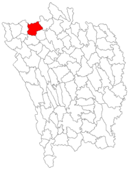
 Location in Vaslui County | |
| Coordinates: 46°50′25″N 27°26′30″E / 46.84028°N 27.44167°E | |
| Country | Romania |
| County | Vaslui |
| Government | |
| • Mayor (2020–2024) | Petru Cristinel Rusu[1] (PNL) |
| Area | 61.1 km2 (23.6 sq mi) |
| Elevation | 120 m (390 ft) |
| Population (2021-12-01)[2] | 7,530 |
| • Density | 120/km2 (320/sq mi) |
| Time zone | EET/EEST (UTC+2/+3) |
| Postal code | 735200 |
| Area code | (+40) 02 35 |
| Vehicle reg. | VS |
| Website | negresti |
Negrești (Romanian pronunciation: [neˈɡreʃtʲ]) is a town in Vaslui County, located in the eastern part of Western Moldavia, a traditional region of Romania. At the 2021 census it had a population of 7,530. Its name comes from distinguished nobleman Negrea, who had worked in the council of Alexander the Good.
The town administers six villages: Căzănești, Cioatele, Glodeni, Parpanița, Poiana, and Valea Mare.
Negrești is situated at an altitude of 120 m (390 ft), on the banks of the Bârlad River and its left tributary, the river Stavnic. It is located in the northern part of Vaslui County, 33 km (21 mi) from the county seat, Vaslui, on the border with Iași County.
| Year | Pop. | ±% |
|---|---|---|
| 1977 | 6,978 | — |
| 1992 | 9,744 | +39.6% |
| 2002 | 10,481 | +7.6% |
| 2011 | 7,897 | −24.7% |
| 2021 | 7,530 | −4.6% |
| Source: Census data | ||
Natives[edit]
- Dumitru Almaș (1908 – 1995), journalist, novelist, historian, and writer
- Maria Păduraru (born 1970), rower
- Emanoil Stratan (born 1940), rower
References[edit]
- ^ "Results of the 2020 local elections". Central Electoral Bureau. Retrieved 16 June 2021.
- ^ "Populaţia rezidentă după grupa de vârstă, pe județe și municipii, orașe, comune, la 1 decembrie 2021" (XLS). National Institute of Statistics.
Wikimedia Commons has media related to Negrești.


