
National Park railway station, Manawatū-Whanganui
Waimarino National Park | |||||||||||
|---|---|---|---|---|---|---|---|---|---|---|---|
 Waimarino National Park Railway Station - 2023 | |||||||||||
| General information | |||||||||||
| Location | National Park, Ruapehu District New Zealand | ||||||||||
| Coordinates | 39°10′33″S 175°23′35″E / 39.17583°S 175.39306°E | ||||||||||
| Elevation | 807 m (2,648 ft) | ||||||||||
| Owned by | KiwiRail | ||||||||||
| Line(s) | North Island Main Trunk | ||||||||||
| Distance | Wellington 346.83 km (215.51 mi) | ||||||||||
| History | |||||||||||
| Opened | 9 November 1908[1] | ||||||||||
| Previous names | Waimarino until 2 May 1926 | ||||||||||
| Services | |||||||||||
| |||||||||||
| Other services | |||||||||||
| |||||||||||
Waimarino National Park railway station is a station on the North Island Main Trunk that serves the area around the town of National Park in New Zealand's Ruapehu District. It is served by KiwiRail's Northern Explorer long distance train between Wellington and Auckland. There is a licensed cafe on the platform.
At an elevation of 806.8 metres (2,647 ft), it was the country's highest station with a scheduled passenger stop (although the now-closed Waiouru Railway Station is higher). About 5 kilometres (3.1 mi) north of the station the railway performs the convoluted dance that is the Raurimu Spiral, one of New Zealand's most impressive feats of engineering.
There was a minor collision in 2007, when one Overlander train reversed into the other.[2]
Scheduled passenger services to Waimarino National Park railway station were suspended from December 2021[3] to 25 September 2022.[4]
History[edit]
Originally the station was called Waimarino (calm waters). On 2 May 1926, the New Zealand Railways renamed the railway station as National Park at the request of the Waimarino County Council. This name had come into common usage, due to the station's proximity to Tongariro National Park, and it also served to avoid confusion with other places called Waimarino.
Plans for the station were approved in 1901 and a 4th class station of 90 ft (27 m) by 17 ft (5.2 m) was built by March 1908, with rooms for a stationmaster, luggage, urinals and ladies. The 240 ft (73 m) by 15 ft (4.6 m) platform was extended to 300 ft (91 m) by 1933, 429 ft (131 m) by 1949 and another 200 ft (61 m) at each end was added in 1955. In 1957 the platform height was 5+1⁄4 in (130 mm) to 9+1⁄2 in (240 mm) above rail level. Between 1959 and 1980 it was raised to 36 cm (14 in) above rail level, using pre-cast sections, at a cost of about £2,830. About 1930 a 110 ft (34 m) verandah was added to the station. From 1910 to 1940 there was a Post Office at the station, including a telephone from 1914. There was also a 40 ft (12 m) by 30 ft (9.1 m) goods shed with verandah, a loading bank, cattle and sheep yards, two 4,000 imp gal (18,000 L) water tanks and a cart approach. There was a tablet and fixed signals. Houses for railway staff and a stationmaster were built between 1908 and 1954. A crossing loop could take 80 wagons and a snowplough was kept at the station.[5]
In the 1960s, National Park became the railhead for the heavy equipment and machinery for the Tongariro Power Scheme Development, with the pumice roads substantially upgraded to take the heavy traffic. The station was also upgraded in 1965, with a 20-ton gantry crane, 40-ton weighbridge, 5 cement silos and a 100 ft (30 m) by 50 ft (15 m) goods shed, built on 11 acres (4.5 ha) of newly drained wetland[5] to the south east of the station.[6] The problem of building on the wetland was also noted in 1911, 1943 and, in 1930, the loading bank was described as being in 'a rough state' after use during building of Chateau Tongariro. In 1949 348 ft (106 m) of drainpipes were laid when sidings were extended.[5]
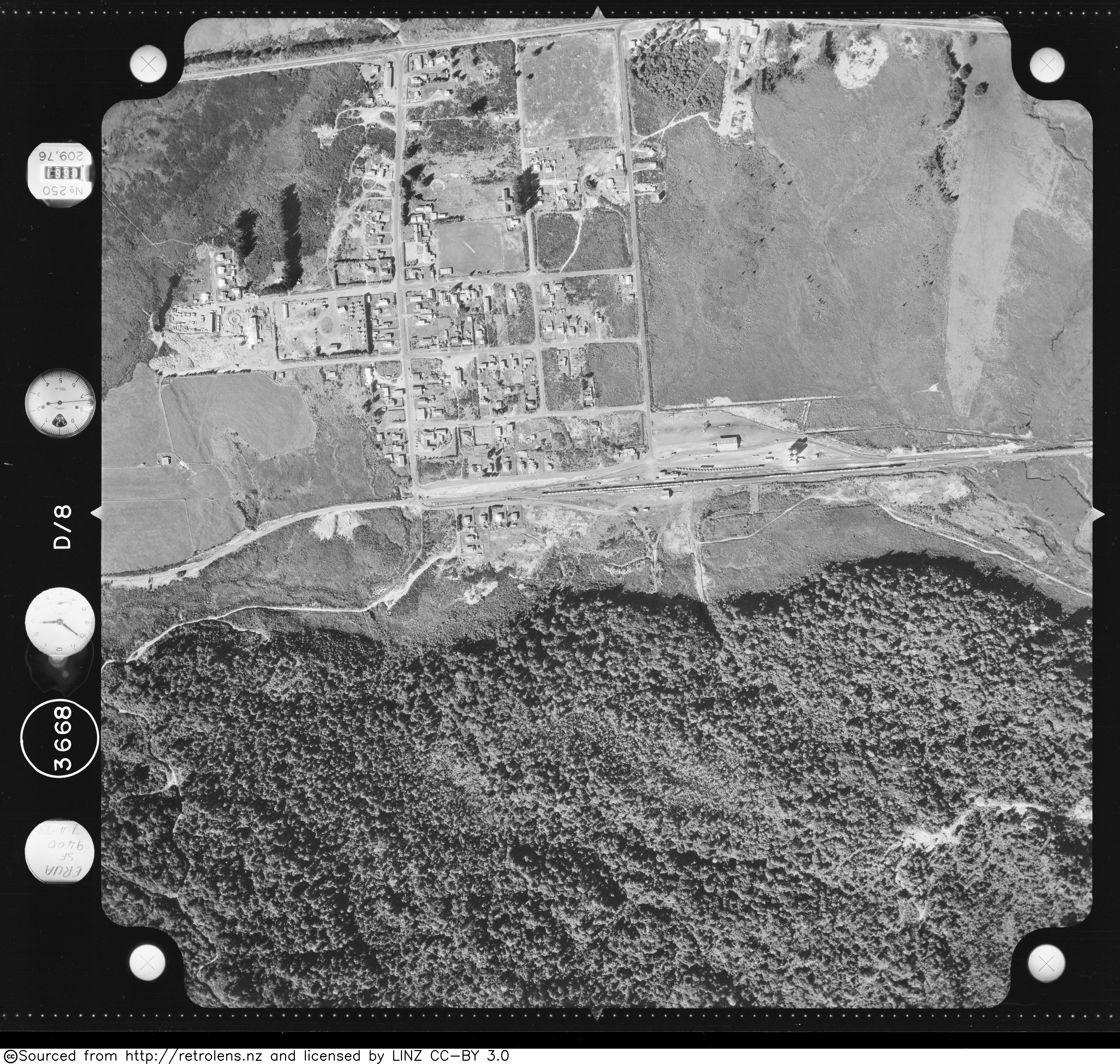
An engine reversing triangle was built in 1912 and remained in 1963,[5] but was overgrown by 1973.[7]
In August 2023, KiwiRail erected new signage at the Railway Station recognising the original name of Waimarino.
Logging[edit]
The opening of the Main Trunk Line in 1908 created a vast opportunity to log and mill the large trees in the native forests with 30 saw mills and associated bush tramways established in the National Park area alone. With the arrival of caterpillar tractors in the 1930s, the extraction process was accelerated with National Park station having one of the greatest throughputs of timber in New Zealand. Today, only one mill is still operating.[8]
.jpg)
Marton Sash and Door Tramway[edit]
Marton Sash and Door Co had a tramway, which ran about 5 km (3.1 mi) south-west from the station.[9] It was powered by an A & G Price 1924 Type Cb 0-4-4-0 from 1932 to 1948, which is now at Ferrymead.[10] The mill opened in 1934.[11] The line was still advertising for staff in 1945.[12] The tramway became part of a 16 km (9.9 mi) cycleway[13] in 2014.[14]
References[edit]
- ^ Names & Opening & Closing Dates of Railway Stations in New Zealand by Juliet Scoble (2012)
- ^ "Report 07-103, passenger express Train 200, collision with stationary passenger express Train 201, National Park" (PDF). 21 March 2007.
- ^ "Urgent calls for long-distance passenger services to stay as KiwiRail cuts operations". Newshub. Retrieved 29 January 2022.
- ^ "Even Greater Journeys for 2022!". Great Journeys of New Zealand. Retrieved 15 April 2022.
- ^ a b c d "Stations" (PDF). NZR Rolling Stock Lists. Retrieved 10 August 2020.
- ^ "Retrolens Survey: SN3668 Photo: 8". 7 April 1973.
- ^ "Retrolens Survey: SN3668 Photo: 8". 7 April 1973.
- ^ "National Park railway station". nzhistory.govt.nz. Retrieved 24 October 2020.
- ^ New Zealand Railway and Tramway Atlas (Fourth ed.). Quail Map Co. 1993. ISBN 0-900609-92-3.
- ^ "Owners". www.trainweb.org. Retrieved 24 October 2020.
- ^ "BURNT OUT. KING COUNTRY CHRONICLE". paperspast.natlib.govt.nz. 9 October 1939. Retrieved 24 October 2020.
- ^ "NEW ZEALAND HERALD". paperspast.natlib.govt.nz. 22 December 1945. Retrieved 24 October 2020.
- ^ "Marton Sash and Door Tramway Trail Mountain Bike Trail, Ohakune, New Zealand". MTB Project. Retrieved 24 October 2020.
- ^ "Public Business" (PDF). Ruapehu District Council. 12 August 2014.
External links[edit]
Photos -