
List of ferry quays in İzmir
The topic of this article may not meet Wikipedia's notability guideline for geographic features. (May 2020) |
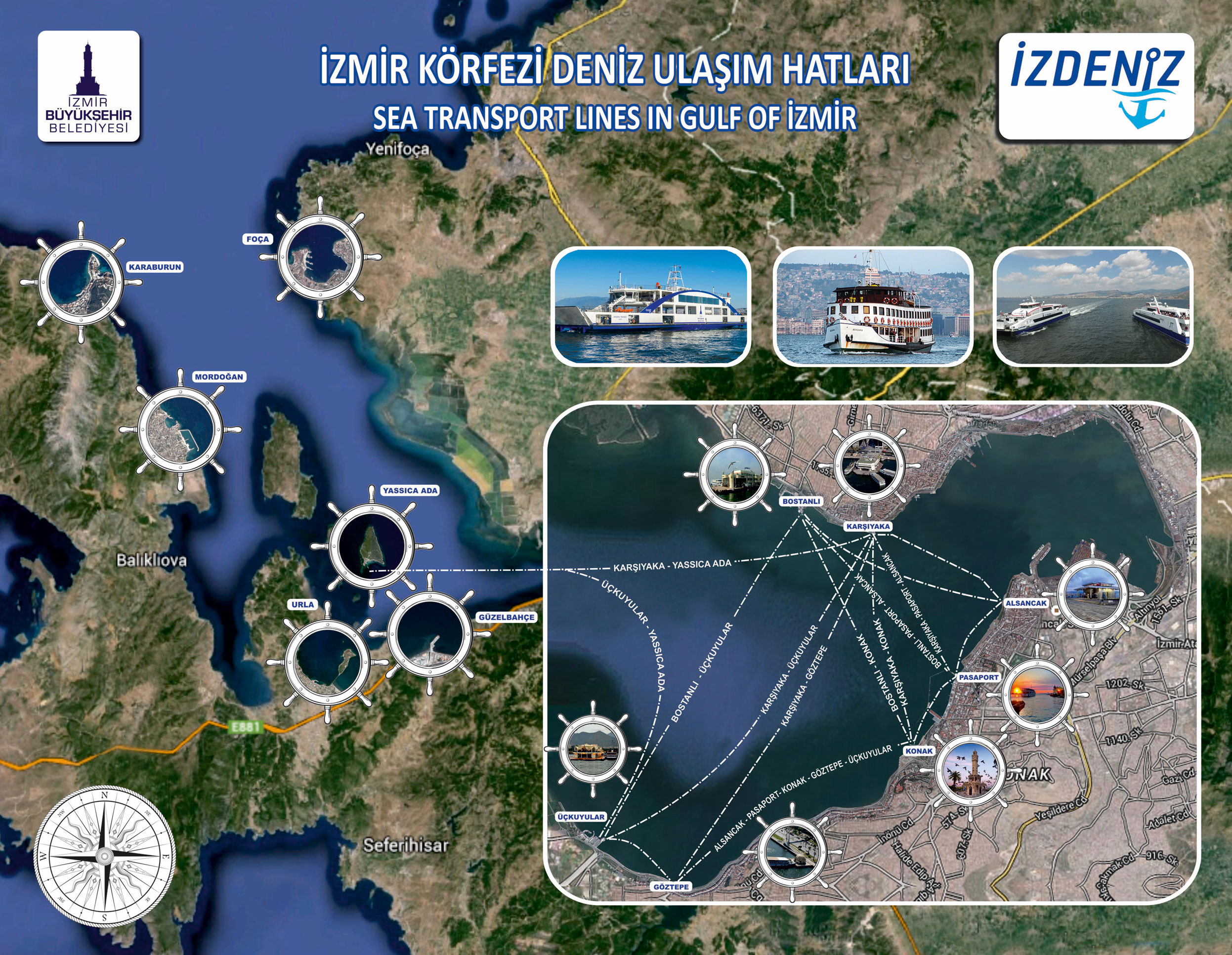
| External image | |
|---|---|
by İzdeniz, updated 2019. |
There are fifteen passenger ferry quays in İzmir, of which nine are in active service in Gulf of İzmir.
Background[edit]
The first ferry services in the Gulf of İzmir were launched in February 1884 by the İzmir Hamidiye Ferry Company.[1][2][3] The piers used in those years were wooden.[2] According to the data of 1915, the Konak-Karşıyaka line was used by 1,100,000 people annually, while 900,000 passengers were carried between Konak and Güzelyalı.[2] The Belgians, who bought the company shares in 1908, changed the name of the company.[2] In 1925, a public company called İzmir Port and Gulf Affairs took over the transportation business.[2] Later, Turkish Maritime Organization became responsible for transport in the gulf.[2][4] At that time, sixty daily services were organized on six lines.[4] İzmir Metropolitan Municipality took over the transportation business in 2000.[4] Today, the company named İzdeniz established by the municipality provides transportation in the gulf.[4] As of 2018, there are nine active ferry quays in the gulf.[5] In 2015, 14,392,982 passengers were carried.[6]
Quays[edit]
Active[edit]
Following is the list of active ferry quays:
Interactive map
| |||||
|---|---|---|---|---|---|
| Name | Image | Coordinates | District | Date opened | Connections |
| Alsancak | 
|
38°26′20.2″N 27°08′26.9″E / 38.438944°N 27.140806°E | Konak | 1950 (first)[7] 2000s (second) |
|
| Bostanlı | 
|
38°27′07.6″N 27°05′51″E / 38.452111°N 27.09750°E | Karşıyaka | 1996[7] | Bus, Tram |
| Göztepe | 
|
38°23′58.4″N 27°05′00.6″E / 38.399556°N 27.083500°E | Konak | 1988[7] | Tram |
| Güzelbahçe | .jpg)
|
38°22′47.0″N 26°53′36.6″E / 38.379722°N 26.893500°E | Güzelbahçe | 2 May 2003 (first)[8] 18 May 2018 (second)[9] |
Bus |
| Karantina | .jpg)
|
38°24′30.7″N 27°06′23.1″E / 38.408528°N 27.106417°E | Konak | 26 December 2018[10] | Tram |
| Karşıyaka | 
|
38°27′17.3″N 27°07′14.2″E / 38.454806°N 27.120611°E | Karşıyaka | 1900s | Bus, Tram |
| Konak | 
|
38°25′07.3″N 27°07′31.7″E / 38.418694°N 27.125472°E | Konak | 1900s | Tram |
| Pasaport | 
|
38°25′43.7″N 27°07′56.7″E / 38.428806°N 27.132417°E | Konak | 1884 | |
| Üçkuyular | 
|
38°24′19.8″N 27°04′15.7″E / 38.405500°N 27.071028°E | Balçova | Bus | |

Seasonal[edit]
| Name | Image | Coordinates | District | Date opened | Connections |
|---|---|---|---|---|---|
| Foça | 38°40′02.8″N 26°45′07.4″E / 38.667444°N 26.752056°E | Foça | 1 August 2015[11] | ||
| Karaburun | 38°38′59.2″N 26°31′00.9″E / 38.649778°N 26.516917°E | Karaburun | 2007 (first)[12] 2016 (second)[13] |
||
| Mordoğan | 38°31′05.1″N 26°37′38.4″E / 38.518083°N 26.627333°E | Karaburun | 6 July 2016[13][14] | ||
| Urla | 38°21′50.2″N 26°46′19.2″E / 38.363944°N 26.772000°E | Urla | 26 June 2017[15] | ||
| Yassıca Ada | 38°24′23.7″N 26°47′39.6″E / 38.406583°N 26.794333°E | Urla | June 2001[12] |
Inactive[edit]
| Name | Image | Coordinates | District | Date opened | Date closed |
|---|---|---|---|---|---|
| Bayraklı | 
|
38°27′48.7″N 27°09′40.9″E / 38.463528°N 27.161361°E | Bayraklı | 6 May 2001[7][16] | 1 June 2016[17][18] |
References[edit]
- ^ "Körfez sularında ilk vapurlar". İzmir Kültür ve Turizm Dergisi. No. 36. April–May 2016. Retrieved 17 April 2020.
- ^ a b c d e f "İzmir Körfez vapurlarının 120 yılı". Milliyet. 9 February 2004. Retrieved 16 October 2015.
- ^ "1700'lü yıllarda Alsancak'ta güncel yaşam". Yeni Asır. 15 April 2014. Retrieved 16 October 2015.
- ^ a b c d "Hakkımızda". izdeniz.com.tr. Archived from the original on 8 September 2017. Retrieved 16 October 2015.
- ^ "Gemiler ve İskeleler". izdeniz.com.tr. Archived from the original on 8 September 2017. Retrieved 2 August 2016.
- ^ "Yıllar ve Yolcu Sayıları". izdeniz.com.tr. Archived from the original on 6 August 2016. Retrieved 2 August 2016.
- ^ a b c d Ürük, Yaşar. "Martı Sevdalısı Bergama Vapuru'nun 50. Yaşına Merhaba". izmirkitap.com. Archived from the original on 25 July 2019. Retrieved 25 July 2019.
- ^ "Güzelbahçe'de vapur sevinci". İzmir Büyükşehir Belediyesi. 2 May 2003. Retrieved 25 July 2019.
- ^ "Güzelbahçe vapuruna kavuşuyor". İzmir Büyükşehir Belediyesi. 17 May 2018. Retrieved 25 July 2019.
- ^ "Körfeze bir iskele daha". İzmir Büyükşehir Belediyesi. 26 December 2018. Retrieved 24 July 2019.
- ^ "İzmir'den Foça'ya vapur seferleri başladı". Hürriyet. 1 August 2015. Retrieved 17 October 2015.
- ^ a b "Yıllar ve Yolcu Sayıları". izdeniz.com.tr. Archived from the original on 6 August 2016. Retrieved 2 August 2016.
- ^ a b "Mordoğan'a vapurla keyifli yolculuk başladı". izmir.bel.tr. 7 July 2016. Archived from the original on 6 August 2016. Retrieved 2 August 2016.
- ^ "Bayram müjdesi İZDENİZ'den geldi". izmir.bel.tr. 4 July 2016. Archived from the original on 18 October 2016. Retrieved 22 April 2017.
- ^ "Körfez'de 'bayram' havası". izmir.bel.tr. 22 June 2017. Archived from the original on 19 November 2017. Retrieved 8 September 2017.
- ^ "Konak'a tünel, Karşıyaka'ye yeni otopark, Bayraklı'ya vapur..." Yeni Asır. 26 April 2001. Retrieved 25 July 2019.
- ^ "Bayraklı İskelesi ne olacak?". İlkses Gazetesi. 3 October 2016. Retrieved 25 July 2019.
- ^ "Bayraklı'ya iskele şoku". Ege Postası. 24 May 2016. Retrieved 25 July 2019.
External links[edit]
- İZDENİZ website