Fyfield, Hampshire
| Fyfield | |
|---|---|
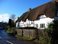
 Thatched cottage in the village | |
Location within Hampshire | |
| Population | 437 (2011 Census including Redenham and Redenham Park)[1] |
| OS grid reference | SU2951646759 |
| District | |
| Shire county | |
| Region | |
| Country | England |
| Sovereign state | United Kingdom |
| Post town | Andover |
| Postcode district | SP11 |
| Dialling code | 01264 |
| Police | Hampshire and Isle of Wight |
| Fire | Hampshire and Isle of Wight |
| Ambulance | South Central |
| UK Parliament | |
Fyfield is a village and civil parish in the Test Valley district of north west Hampshire, England. Its nearest town is Andover.
Part of Redenham Park lies within the parish.
References[edit]
- ^ "Civil Parish population 2011". Neighbourhood Statistics. Office for National Statistics. Retrieved 18 December 2016.
- The geographic coordinates are from the Ordnance Survey.
External links[edit]
![]() Media related to Fyfield, Hampshire at Wikimedia Commons
Media related to Fyfield, Hampshire at Wikimedia Commons


