
Džungľa
This article needs additional citations for verification. (August 2023) |
Džungľa | |
|---|---|
Borough | |
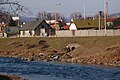
 A stretch of the Hornád river flowing through the Džungľa borough (February 2013) | |
 Flag  Coat of arms | |
 Location within Košice | |
| Country | Slovakia |
| Region | Košice |
| District | Košice I |
| Locality | 1929 (first known record) |
| Borough | 1990 |
| Area | |
| • Total | 0.47 km2 (0.18 sq mi) |
| Elevation | 209 m (686 ft) |
| Population (31 December 2017) | |
| • Total | 697 |
| • Density | 1,500/km2 (3,800/sq mi) |
| Population by ethnicity (2011) | |
| • Slovak | 76.9% |
| • Roma | 2.1% |
| • Hungarian | 0.8% |
| • Other | 1.9% |
| • Unreported | 18.3% |
| Population by religion (2011) | |
| • Roman Catholic | 42.2% |
| • Greek Catholic | 6.6% |
| • Orthodox | 4.5% |
| • Jehovah's Witness | 2.7% |
| • Other | 3.9% |
| • Non-religious | 20% |
| • Unreported | 20.1% |
| Postal code | 040 13 |
| Area code | +421-55 |
| Car plate | KE |
| Website | N/A |
| Source [3] | |
Džungľa (literally: "Jungle", Hungarian: Dzsungel) is a borough (city ward) of Košice, Slovakia. The borough is situated in the Košice I district and lies to the northeast of the neighbouring borough of Košice Old Town, at an altitude of roughly 209 metres (686 ft) above sea level.
Džungľa gained its distinctive name in the interwar period and was made an official borough in the early 1990s. It is the smallest of all 22 of Košice's boroughs, and is also one of the least populous overall.
The borough is largely focused on housing (with a few hundred residents), industrial areas and shopping centres.
History[edit]
Today's borough of Džungľa developed during the interwar period, its nickname (later adopted as an official name) first appeared in the late 1920s.
Džungľa became a separate borough of Košice, as part of the Košice I district, in 1990.
Statistics[edit]
- Area: 0.47 square kilometres (0.18 sq mi)
- Population: 697 (December 2017)
- Density of population: 1500/km2 (December 2017)
- District: Košice I
- Mayor: Adriana Šebeščáková Balogová (as of 2018 elections)
Gallery[edit]
Photos
-
 Confluence of the river Hornád and the local stream Moňok, older housing at the riverfront
 -
 A local shopping centre in Džungľa
 -
 A "Tesco Extra" shopping centre in Džungľa
 -
 Interior of a local shopping centre
 -
 Interior of a local shopping centre


Maps of the area
-
 A 1912 map of the Džungľa locality
 -
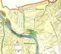
 A modern map of the Džungľa borough


References[edit]
- ^ SODB - Košice - Džungľa, 2011
- ^ SODB - Košice - Džungľa, 2011
- ^ Mestská a obecná štatistika SR (urgently needs an updated statistics link for 2018) Archived 2007-04-27 at the Wayback Machine
External links[edit]
48°44′14″N 21°16′5″E / 48.73722°N 21.26806°E
| International | |
|---|---|
| National | |
This Košice Region geography article is a stub. You can help Wikipedia by expanding it. |