
Parish of St Lawrence
| St Lawrence New South Wales | |||||||||||||||
|---|---|---|---|---|---|---|---|---|---|---|---|---|---|---|---|
 Location in Sydney city highlighted in magenta | |||||||||||||||
| Established | 1835 | ||||||||||||||
| LGA(s) | City of Sydney | ||||||||||||||
| County | Cumberland | ||||||||||||||
| Hundred (former) | Sydney | ||||||||||||||
| |||||||||||||||
St Lawrence Parish is one of the 57 parishes of Cumberland County, New South Wales, Australia, a cadastral unit for use on land titles. It is one of the four small parishes in the Sydney city area. Unlike the other three parishes, St Lawrence was not named after a New Testament saint but after St Lawrence, the second Bishop of Canterbury, successor to St Augustine of Canterbury, presumably very familiar to Bishop Broughton from his time in Canterbury. The church in the parish was dedicated by the bishop as Christ Church. Later, as it became more "tractarian" and Anglo-Catholic, the name of the parish was added to that of the church. However, by then, St Lawrence was understood to refer to the only saint of that name in the Book of Common Prayer, St Lawrence, (in the Prayer Book, Archdeacon) of Rome, and St Laurence of Rome (now spelt with "u") has since been considered the patron saint of the church. .[1]
The area of the parish includes Central station, Museum station, the southern part of Hyde Park below Park street, and Prince Alfred Park. The parish is bounded by George Street in the west, Park Street and a small part of William Street in the north, a line from the intersection of Yurong and William streets to the intersection of Albion and Elizabeth streets in the east, also part of Elizabeth Street forms the boundary further south, as well as Chalmers Street. Regent Street is the boundary in the south west.[2] It includes the Anzac Memorial.[3] The parish is relatively thin east-west, so that Central railway station nearly covers the entire width of the parish.
Images[edit]
Images of locations in the Parish of St Lawrence:
-

-
 Anzac Memorial, and the surrounding southern part of Hyde Park
 -

-
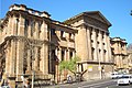 The Australian Museum is at the north-eastern tip of the parish


33°52′26″S 151°12′23″E / 33.87389°S 151.20639°E
References[edit]
- ^ The Naming of the Parish, Christ Church of St. Laurence
- ^ Information obtained from maps available at the NSW Dept. of Lands Parish map preservation project Archived 29 August 2007 at the Wayback Machine
- ^ Anzac memorial building act 1923, Austlii
- "St Lawrence". Geographical Names Register (GNR) of NSW. Geographical Names Board of New South Wales.
| International | |
|---|---|
| National | |
This article related to the geography of Sydney is a stub. You can help Wikipedia by expanding it. |