
File:Wojewodztwo slaskie a Slask.png
Original file (1,016 × 1,169 pixels, file size: 346 KB, MIME type: image/png)
| This is a file from the Wikimedia Commons. Information from its description page there is shown below. Commons is a freely licensed media file repository. You can help. |
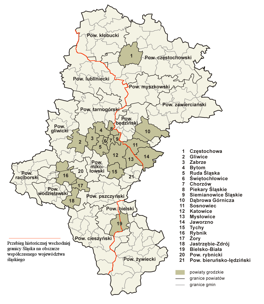
Wyraźne błędy na mapie: 1. pow. lubliniecki: gmina Herby, miejscowość Herby - granica Śląska biegła między Herbami Śląskimi a Polskimi, nie obejmując Herbów Polskich (na mapie zaznaczono błędny przebieg wg współczesnych granic gminy i powiatu) - należy ściąć trójkąt. 2. pow. lubliniecki: gmina Herby, miejscowość Łebki - granica Śląska biegła wzdłuż Liswarty, nie obejmując terenu wsi Łebki(na mapie zaznaczono błędny przebieg wg współczesnych granic gminy i powiatu) - należy ściąć trójkąt do biegu rzeki. 3. pow. bielski: gmina Wilkowice, miejscowość Bystra - granica biegła między Bystrą Śląską a Bystrą Krakowską wzdłuż rzeki Białki(na mapie jest błędny przebieg wg granic gminy-powiatu Bielsko-Biała) - należy przenieść czerwoną linię na rzekę Białkę. 4. pow. tarnogórski: gminy Świerklaniec i Ożarowice - granica biegła wzdłuż rzeki Brynicy i przez środek Jeziora Świerklaniec, nie obejmując obecnej gminy Ożarowice(na mapie zaznaczono błędny przebieg wg współczesnych granic powiatu) - należy przenieść czerwoną linię na zachód aż do biegu rzeki Brynicy.
Summary
| Description |
Polski: Granica między Rzecząpospolitą Obojga Narodów a Koroną Czeską na mapie obecnego województwa śląskiego, uznawana za nowożytną granicę między Śląskiem a Małopolską |
| Date | |
| Source | Own work - according to http://posselt-landkarten.heimat.eu/21.jpg + http://www.mapy.cz/#mm=TtTcPA@x=143505408@y=134871040@z=9 |
| Author | border Kirk, map from File:Śląskie administracja.png by Aotearoa. |
| Other versions |
 |
Licensing

|
Permission is granted to copy, distribute and/or modify this document under the terms of the GNU Free Documentation License, Version 1.2 or any later version published by the Free Software Foundation; with no Invariant Sections, no Front-Cover Texts, and no Back-Cover Texts. A copy of the license is included in the section entitled GNU Free Documentation License. |
| This file is licensed under the Creative Commons Attribution-Share Alike 3.0 Unported license. | ||
| ||
| This licensing tag was added to this file as part of the GFDL licensing update. |
File history
Click on a date/time to view the file as it appeared at that time.
| Date/Time | Thumbnail | Dimensions | User | Comment | |
|---|---|---|---|---|---|
| current | 22:31, 15 April 2008 | | 1,016 × 1,169 (346 KB) | Kirk979 | |
| 00:02, 8 August 2006 |  | 538 × 599 (164 KB) | Marcoos~commonswiki | Based on [http://cs.wikipedia.org/wiki/Soubor:Pr%C5%AFb%C4%9Bh_historick%C3%A9_Slezsk%C3%A9_hranice_na_%C3%BAzem%C3%AD_modern%C3%ADho_Slezsk%C3%A9ho_vojvodstv%C3%AD.png Czech map] by Kirk and on Image:Woj slaskie adm.png by User:Niki_K. |
File usage
Global file usage
The following other wikis use this file:
- Usage on crh.wikipedia.org