
File:Wien - Wasserbaulabor der BOKU.JPG

Size of this preview: 800 × 519 pixels. Other resolutions: 320 × 208 pixels | 640 × 415 pixels | 1,024 × 664 pixels | 1,280 × 830 pixels | 2,560 × 1,660 pixels | 4,200 × 2,724 pixels.
Original file (4,200 × 2,724 pixels, file size: 8.66 MB, MIME type: image/jpeg)
| This is a file from the Wikimedia Commons. Information from its description page there is shown below. Commons is a freely licensed media file repository. You can help. |
Summary
| Description |
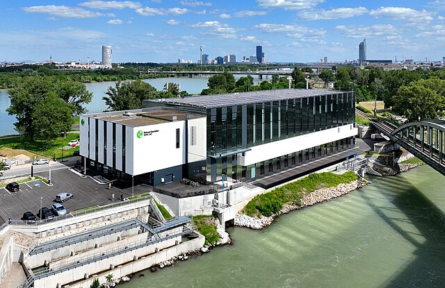
Deutsch: Nordwestansicht des Wasserbaulabors der BOKU am Brigittenauer Sporn im 20. Wiener Gemeindebezirk Brigittenau und links unten die 2017 eröffnete Fischwanderhilfe, die die Donau (im Hintergrund) mit dem Donaukanal verbindet.
Nach einer Bauzeit von rund drei Jahren wurde das Wasserbaulabor am 12. Juni 2023 feierlich eröffnetː [1]. Initiator und Projektleiter war Helmut Habersack vom Institut für Wasserbau, Hydraulik und Fließgewässerforschung. Mit 10 m³ Durchfluss pro Sekunde ohne Pumpen besitzt das neue Wasserbaulabor ein weltweites Alleinstellungsmerkmal. Die Errichtungskosten betrugen rd. 49 Millionen Euroː [2]. English: River Laboratory of the University of Natural Resources and Life Sciences in Vienna. |
| Date | |
| Source | Own work |
| Author | C.Stadler/Bwag |
| Permission (Reusing this file) |
Deutsch: Hallo, du darfst mein Foto kostenlos nutzen, aber nenne mich bitte als Fotograf, beispielsweise „Foto: C.Stadler/Bwag“ oder © C.Stadler/Bwag; CC-BY-SA-4.0. Auf mehr Angaben bestehe ich nicht - im Gegensatz zu manch anderen, die die Vorgaben der unten angeführten Lizenzierung auf Punkt und Beistrich einfordern. English: Feel free to use my photos, but please mention me as the author like © C.Stadler/Bwag or © C.Stadler/Bwag; CC-BY-SA-4.0 (that's good enough) and if you want send me a message: bwag@gmx.net. |
| Object location | | View this and other nearby images on: OpenStreetMap |
|---|
| Camera location | | View this and other nearby images on: OpenStreetMap |
|---|
Licensing
I, the copyright holder of this work, hereby publish it under the following license:
This file is licensed under the Creative Commons Attribution-Share Alike 4.0 International license.
- You are free:
- to share – to copy, distribute and transmit the work
- to remix – to adapt the work
- Under the following conditions:
- attribution – You must give appropriate credit, provide a link to the license, and indicate if changes were made. You may do so in any reasonable manner, but not in any way that suggests the licensor endorses you or your use.
- share alike – If you remix, transform, or build upon the material, you must distribute your contributions under the same or compatible license as the original.
File history
Click on a date/time to view the file as it appeared at that time.
| Date/Time | Thumbnail | Dimensions | User | Comment | |
|---|---|---|---|---|---|
| current | 18:08, 12 June 2023 | | 4,200 × 2,724 (8.66 MB) | Bwag | == {{int:filedesc}} == {{Information |Description= {{de|1=Nordwestansicht des Wasserbaulabors der BOKU am Brigittenauer Sporn im 20. Wiener Gemeindebezirk Brigittenau und links unten die 2017 eröffnete Fischwanderhilfe.<br/>Nach einer Bauzeit von rund drei Jahren wurde das Wasserbaulabor am 12. Juni 2023 feierlich eröffnetː [https://www.ots.at/presseaussendung/OTS_20230605_OTS0091/einladung-zur-eroeffnung-des-boku-wasserbaulabors-am-brigittenauer-sporn]. Initiator und Projektleiter war Helmu... |
File usage
The following pages on the English Wikipedia use this file (pages on other projects are not listed):
Global file usage
The following other wikis use this file:
- Usage on de.wikipedia.org