
File:Txu-pclmaps-oclc-22834566 g-7b.jpg

Size of this preview: 800 × 573 pixels. Other resolutions: 320 × 229 pixels | 640 × 459 pixels | 1,024 × 734 pixels | 1,280 × 917 pixels | 2,560 × 1,834 pixels | 9,446 × 6,769 pixels.
Original file (9,446 × 6,769 pixels, file size: 37.47 MB, MIME type: image/jpeg)
| This is a file from the Wikimedia Commons. Information from its description page there is shown below. Commons is a freely licensed media file repository. You can help. |
Summary
| Description |
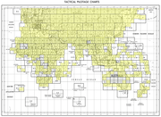
English: TPC G-7B China [Not for navigational use] U.S. Defense Mapping Agency Aerospace Center, compiled 1990 (31.2MB)
Tactical Pilotage Chart Series - World 1:500,000 Scale Includes parts of Xinjiang Uyghur Autonomous Region and Tibet Autonomous Region |
|||||||||
| Date |
Air Information Current Through: 27 February 1990 Compiled: March 1990 Lithographed: October 1990 University of Texas at Austin Library: September 1991 Scanned: 2011-10-05 06:35:51 |
|||||||||
| Source | TPC G-7B (Archived Link [2]) | |||||||||
| Creator | ||||||||||
| Geotemporal data | ||||||||||
| Bounding box |
|
|||||||||
| Georeferencing | ||||||||||
-
 Index Map

Licensing
This work is in the public domain in the United States because it is a work prepared by an officer or employee of the United States Government as part of that person’s official duties under the terms of Title 17, Chapter 1, Section 105 of the US Code.
Note: This only applies to original works of the Federal Government and not to the work of any individual U.S. state, territory, commonwealth, county, municipality, or any other subdivision. This template also does not apply to postage stamp designs published by the United States Postal Service since 1978. (See § 313.6(C)(1) of Compendium of U.S. Copyright Office Practices). It also does not apply to certain US coins; see The US Mint Terms of Use.
|
 | |
| This file has been identified as being free of known restrictions under copyright law, including all related and neighboring rights. | ||
File history
Click on a date/time to view the file as it appeared at that time.
| Date/Time | Thumbnail | Dimensions | User | Comment | |
|---|---|---|---|---|---|
| current | 11:48, 13 June 2021 | | 9,446 × 6,769 (37.47 MB) | Geographyinitiative | cropped blank (white) edges from scanner |
| 11:41, 27 December 2019 |  | 9,639 × 7,210 (29.81 MB) | Geographyinitiative | User created page with UploadWizard |
File usage
The following pages on the English Wikipedia use this file (pages on other projects are not listed):
Global file usage
The following other wikis use this file:
- Usage on bn.wiktionary.org
- Usage on en.wiktionary.org
- Usage on ru.wikipedia.org
- Usage on zh.wiktionary.org