
File:Slovakia borderPoland.png
Size of this preview: 800 × 323 pixels. Other resolutions: 320 × 129 pixels | 1,000 × 404 pixels.
Original file (1,000 × 404 pixels, file size: 46 KB, MIME type: image/png)
| This is a file from the Wikimedia Commons. Information from its description page there is shown below. Commons is a freely licensed media file repository. You can help. |
Summary
| Description |
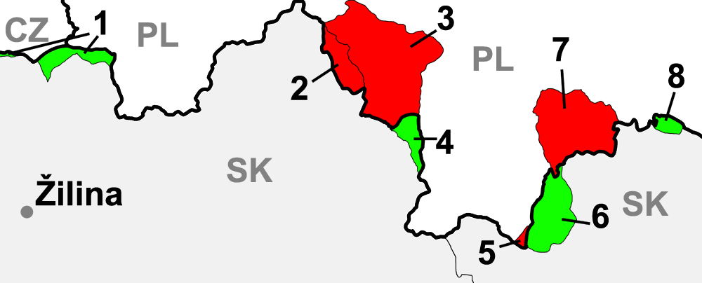
English: map of Slovakia with border-changes in the north against Poland.
Legend
Polski: Mapa przedstawiająca zmiany przebiegu granicy między dzisiejszymi Polską i Słowacją w pierwszej połowie XX wieku.
Legenda
Slovenčina: Mapa sporných území na hranici Slovenska a Poľska počas prvej polovice 20 storočia.
Legenda:
|
| Date | |
| Source | Own work |
| Author | Murli |
| Other versions |
|
Licensing
I, the copyright holder of this work, hereby publish it under the following licenses:

|
Permission is granted to copy, distribute and/or modify this document under the terms of the GNU Free Documentation License, Version 1.2 or any later version published by the Free Software Foundation; with no Invariant Sections, no Front-Cover Texts, and no Back-Cover Texts. A copy of the license is included in the section entitled GNU Free Documentation License. |
| This file is licensed under the Creative Commons Attribution-Share Alike 3.0 Unported license. | ||
| ||
| This licensing tag was added to this file as part of the GFDL licensing update. |
This file is licensed under the Creative Commons Attribution-Share Alike 2.5 Generic, 2.0 Generic and 1.0 Generic license.
- You are free:
- to share – to copy, distribute and transmit the work
- to remix – to adapt the work
- Under the following conditions:
- attribution – You must give appropriate credit, provide a link to the license, and indicate if changes were made. You may do so in any reasonable manner, but not in any way that suggests the licensor endorses you or your use.
- share alike – If you remix, transform, or build upon the material, you must distribute your contributions under the same or compatible license as the original.
You may select the license of your choice.
File history
Click on a date/time to view the file as it appeared at that time.
| Date/Time | Thumbnail | Dimensions | User | Comment | |
|---|---|---|---|---|---|
| current | 10:37, 8 May 2015 | 1,000 × 404 (46 KB) | RokerHRO | optipng -o7 -i0 → 21.38% decrease | |
| 13:20, 15 April 2006 | 1,000 × 404 (59 KB) | Murli | corrected border changes around Skalité | ||
| 11:09, 15 April 2006 | 1,000 × 404 (57 KB) | Murli | better version - czech border added and country codes inserted | ||
| 23:11, 14 April 2006 | 1,000 × 404 (54 KB) | Murli | *map of Slovakia with border-changes in the north against Poland *selfprovided on April 15th, 2006 *1 - Skalité territories, from 1 november 1938 - 21. november 1939 to Poland *2 - Lipnica Wiełka territories, from 1918 - 12 march 1924 part of Slovakia, |
File usage
The following pages on the English Wikipedia use this file (pages on other projects are not listed):
Global file usage
The following other wikis use this file:
- Usage on azb.wikipedia.org
- Usage on be-tarask.wikipedia.org
- Usage on be.wikipedia.org
- Usage on cs.wikipedia.org
- Usage on da.wikipedia.org
- Usage on de.wikipedia.org
- Usage on eo.wikipedia.org
- Usage on fr.wikipedia.org
- Usage on hu.wikipedia.org
- Usage on id.wikipedia.org
- Usage on it.wikipedia.org
- Usage on ko.wikipedia.org
- Usage on pl.wikipedia.org
- Usage on pt.wikipedia.org
- Usage on ro.wikipedia.org
- Usage on ru.wikipedia.org
- Usage on sk.wikipedia.org
- Usage on sr.wikipedia.org
- Usage on uk.wikipedia.org