
File:Saint Martin map.svg

Size of this PNG preview of this SVG file: 800 × 558 pixels. Other resolutions: 320 × 223 pixels | 640 × 447 pixels | 1,024 × 715 pixels | 1,280 × 894 pixels | 2,560 × 1,787 pixels | 1,060 × 740 pixels.
Original file (SVG file, nominally 1,060 × 740 pixels, file size: 598 KB)
| This is a file from the Wikimedia Commons. Information from its description page there is shown below. Commons is a freely licensed media file repository. You can help. |
Summary
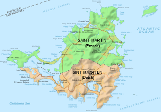
| Description | Map of of the island of St Martin, with political division | ||
| Date | |||
| Source | Saint-Martin Island map-en.svg | ||
| Author | Hogweard | ||
| Permission (Reusing this file) |
I, the copyright holder of this work, hereby publish it under the following licenses: This file is licensed under the Creative Commons Attribution-Share Alike 3.0 Unported license.
You may select the license of your choice. |

File history
Click on a date/time to view the file as it appeared at that time.
| Date/Time | Thumbnail | Dimensions | User | Comment | |
|---|---|---|---|---|---|
| current | 10:45, 29 April 2020 | | 1,060 × 740 (598 KB) | Hogweard | Labels |
| 10:35, 29 April 2020 |  | 1,060 × 740 (595 KB) | Hogweard | {{Information |description=Map of of the island of St Martin, with political division |date=2020-04-29 |source={{f|Saint-Martin Island map-en.svg}} |author={{u|Hogweard}} |permission={{self|cc-by-sa-3.0|GFDL}} |other versions= }} Category:Maps of Saint-Martin |
File usage
The following pages on the English Wikipedia use this file (pages on other projects are not listed):
Global file usage
The following other wikis use this file:
- Usage on ar.wikipedia.org
- Usage on es.wikipedia.org
- Usage on he.wikipedia.org
- Usage on incubator.wikimedia.org
- Usage on lv.wikipedia.org
- Usage on nl.wikipedia.org
- Usage on pl.wikipedia.org
- Usage on shn.wikipedia.org
- Usage on sr.wikipedia.org
- Usage on www.wikidata.org