File:Maramures Josephinische Landesaufnahme 1782-1785 Background.jpg
Page contents not supported in other languages.
This is a file from the Wikimedia Commons
From Wikipedia, the free encyclopedia

Original file(800 × 781 pixels, file size: 317 KB, MIME type: image/jpeg)

Summary

Description
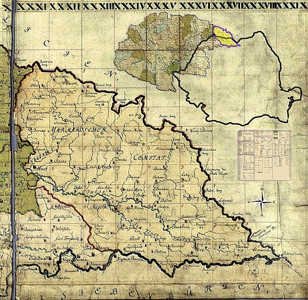
Română: Miniatură pentru background la formatul senzitiv al harţii iozefine a Maramureşului, 1782-1785.
Date
Source Own work
Author Asybaris01
Permission
(Reusing this file)
I, the copyright holder of this work, hereby publish it under the following licenses:
w:en:Creative Commons
attribution share alike
This file is licensed under the Creative Commons Attribution-Share Alike 3.0 Unported license.
You are free:
  • to share – to copy, distribute and transmit the work
  • to remix – to adapt the work
Under the following conditions:
  • attribution – You must give appropriate credit, provide a link to the license, and indicate if changes were made. You may do so in any reasonable manner, but not in any way that suggests the licensor endorses you or your use.
  • share alike – If you remix, transform, or build upon the material, you must distribute your contributions under the same or compatible license as the original.
GNU head Permission is granted to copy, distribute and/or modify this document under the terms of the GNU Free Documentation License, Version 1.2 or any later version published by the Free Software Foundation; with no Invariant Sections, no Front-Cover Texts, and no Back-Cover Texts. A copy of the license is included in the section entitled GNU Free Documentation License.
You may select the license of your choice.

Clickable Map of the Maramureş County

Clickable maps of the Grand Duchy of TransylvaniaKingdom of Hungary counties(clickable map)RomâniaPage 31-01: Alsóhidegpatak / FelsõhidegpatakPage 31-02:Page 31-03:Page 31-04:Page 31-05:Page 31-06:Page 31-07:Page 31-08:Page 32-01:Page 32-02:Page 32-03:Page 32-04:Page 32-05:Page 32-06:Page 32-07:Page 32-08:Page 33-01:Page 33-02: Poiana SinevirPage 33-03:Page 33-04:Page 33-05:Page 33-06:Page 33-07: Apşa de Jos, Câmpulung la Tisa, Peri, Neaga, Criva Mare, Criva Mică, Săpânţa, Sarasău, Ocna Slatina, Remeţi,Page 33-08: Sighetu Marmaţiei, Ocna Slatina,Page 33-09: Deseşti, MaraPage 33-10: Chiuzbaia, Baia Sprie, Ferneziu, Negreia, Şurdeşti, Satu Nou de Sus, Tăuţii de SusPage 34-01:Page 34-02:Page 34-03:Page 34-04:Page 34-05:Page 34-06:Page 34-07:Page 34-08:Page 34-09:Page 35-01: EmptyPage 35-02: Frasin, TranscarpatiaPage 35-03: Frasin, TranscarpatiaPage 35-04: RahăuPage 35-05: 	Tribusa AlbaPage 35-06: Petrova, Rona de SusPage 35-07: Leordina, Petrova, Rozavlea, Ruscova, Strâmtura, Şieu, Vişeu de JosPage 35-08: Botiza, Bocicoel, Dragomireşti, Ieud, Bogdan Vodă, Poienile Şieului, SălişteaPage 35-09: EmptyPage 36-01: EmptyPage 36-02: EmptyPage 36-03: EmptyPage 36-04: EmptyPage 36-05: Poienile de sub MuntePage 36-06: Vişeu de Jos, Vişeu de Mijloc, Vişeu de SusPage 36-07: Mănăstirea Moiseiului, Moisei, Săcel, Săliştea de SusPage 36-08: EmptyPage 37-01: EmptyPage 37-02: EmptyPage 37-03: EmptyPage 37-04: BorşaPage 37-05: EmptyPage 38-01: EmptyPage 38-02: EmptyPage 38-03:Page 39-01: EmptyRO/HU/DE/LegendOriginal maps of the Kingdom of Hungary
Josephinische Landesaufnahme. Senzitive map of the Maramureş county, 1782-1785. (Click on the desired quadrant)

Captions

Add a one-line explanation of what this file represents

Items portrayed in this file

depicts

8 March 2010

File history

Click on a date/time to view the file as it appeared at that time.

Date/TimeThumbnailDimensionsUserComment
current21:19, 8 March 2010Thumbnail for version as of 21:19, 8 March 2010800 × 781 (317 KB)Asybaris01{{Information |Description={{ro|1=Miniatură pentru background la formatul senzitiv al harţii iozefine a Maramureşului, 1782-1785.}} |Source={{own}} |Author=Asybaris01 |Date
The following pages on the English Wikipedia use this file (pages on other projects are not listed):

Global file usage

The following other wikis use this file:

Metadata