
File:Kulturareale.png

Size of this preview: 800 × 434 pixels. Other resolutions: 320 × 174 pixels | 640 × 347 pixels | 1,024 × 556 pixels | 1,280 × 695 pixels | 2,560 × 1,390 pixels | 4,779 × 2,594 pixels.
Original file (4,779 × 2,594 pixels, file size: 3.5 MB, MIME type: image/png)
| This is a file from the Wikimedia Commons. Information from its description page there is shown below. Commons is a freely licensed media file repository. You can help. |
Summary
| Description |
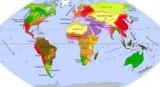
Deutsch: Karte von Kulturarealen
QuellenKartographie:
Datengrundlagen:
English: Cultural areas of the world as defined by Whitten and Hunter (shown with bold borders; associated with traditional economic forms, also shown in colors) |
| Date | |
| Source | Own work |
| Author | Ökologix |
Licensing
I, the copyright holder of this work, hereby publish it under the following license:
This file is licensed under the Creative Commons Attribution-Share Alike 3.0 Unported license.
- You are free:
- to share – to copy, distribute and transmit the work
- to remix – to adapt the work
- Under the following conditions:
- attribution – You must give appropriate credit, provide a link to the license, and indicate if changes were made. You may do so in any reasonable manner, but not in any way that suggests the licensor endorses you or your use.
- share alike – If you remix, transform, or build upon the material, you must distribute your contributions under the same or compatible license as the original.
File history
Click on a date/time to view the file as it appeared at that time.
| Date/Time | Thumbnail | Dimensions | User | Comment | |
|---|---|---|---|---|---|
| current | 06:02, 14 October 2014 | | 4,779 × 2,594 (3.5 MB) | Fährtenleser | Vorherige Karte mischte verschiedene Modelle unterschiedlicher Autoren. Nunmehr ausschließlich basierend auf dem Weltmodell von Hunter und Whitten |
| 06:14, 8 July 2014 |  | 2,000 × 1,086 (1 MB) | Fährtenleser | Benennung der zugrundeliegenden Modelle in Karte aufgenommen | |
| 09:17, 5 December 2013 |  | 2,000 × 1,086 (983 KB) | Fährtenleser | Afrika u. Südamerika verändert (s. neue Quellen), div. „kosmetische" Verbesserungen | |
| 11:26, 23 November 2013 |  | 2,000 × 1,086 (933 KB) | Fährtenleser | Europa verändert (siehe Quellen) | |
| 05:49, 22 September 2013 |  | 2,000 × 1,086 (740 KB) | Fährtenleser | Die Sámi werden zu den uralischen Völkern gerechnet, die wiederum zum sibirischen Kulturareal gehören. Quelle: Harald Haarmann: ''Kleines Lexikon der Völker.'' C. H. Beck, München 2004. | |
| 15:30, 14 September 2013 |  | 2,000 × 1,086 (741 KB) | Fährtenleser | {{Information |Description ={{de|1=Karte der indigenen Kulturareale ==Quellen== ===Kartographie:=== * Eckert VI-Projektion (nahezu flächentreu, realistische Größenverhältnisse, relativ wenig verzerrt), erstellt mit [http://www.geo.dianacht.de ge... |
File usage
The following pages on the English Wikipedia use this file (pages on other projects are not listed):
Global file usage
The following other wikis use this file:
- Usage on de.wikipedia.org
- Usage on fa.wikipedia.org
- Usage on fr.wikipedia.org
- Usage on he.wikipedia.org
- Usage on hr.wikipedia.org
- Usage on ru.wikipedia.org
- Usage on zh.wikipedia.org