
File:Grenzmark PW.png

Size of this preview: 439 × 599 pixels. Other resolutions: 176 × 240 pixels | 352 × 480 pixels | 563 × 768 pixels | 751 × 1,024 pixels | 1,299 × 1,772 pixels.
Original file (1,299 × 1,772 pixels, file size: 271 KB, MIME type: image/png)
| This is a file from the Wikimedia Commons. Information from its description page there is shown below. Commons is a freely licensed media file repository. You can help. |
Summary
| Description |
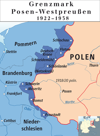
English: Posen-West Prussia (1922–1938)
Deutsch: Grenzmark Posen-Westpreußen (1922–1938) |
| Date | |
| Source | own drawing/Source of Information: Putzger – Historischer Weltatlas, 89. Auflage, 1965; Westermanns Großer Atlas zur Weltgeschichte, 1969; Haacks geographischer Atlas. VEB Hermann Haack Geographisch-Kartographische Anstalt, Gotha/Leipzig, 1. Auflage, 1979. |
| Author | Ziegelbrenner |
| Permission (Reusing this file) |
GNU FDL |
| Other versions |
.png)

|
This map has been made or improved in the German Kartenwerkstatt (Map Lab). You can propose maps to improve as well.
|
Licensing
| I, the copyright holder of this work, release this work into the public domain. This applies worldwide. In some countries this may not be legally possible; if so: I grant anyone the right to use this work for any purpose, without any conditions, unless such conditions are required by law. |
File history
Click on a date/time to view the file as it appeared at that time.
| Date/Time | Thumbnail | Dimensions | User | Comment | |
|---|---|---|---|---|---|
| current | 11:31, 14 February 2012 | | 1,299 × 1,772 (271 KB) | Ziegelbrenner | 2012-02-14 |
| 15:06, 13 February 2012 |  | 1,772 × 2,215 (378 KB) | Ziegelbrenner | {{Information |Description ={{en|1=Posen-West Prussia (1922–1938)}} {{de|1=Grenzmark Posen-Westpreußen (1922–1938)}} |Source ={{own}} |Author =Ziegelbrenner |Date =2012-0213 |Permission =GNU FDL |
File usage
The following pages on the English Wikipedia use this file (pages on other projects are not listed):
Global file usage
The following other wikis use this file:
- Usage on ca.wikipedia.org
- Usage on de.wikipedia.org
- Usage on fa.wikipedia.org
- Usage on fr.wikipedia.org
- Usage on pl.wikipedia.org
- Usage on sv.wikipedia.org
- Usage on zh.wikipedia.org