
File:Cité scientifique Lille Nord de France.jpg

Size of this preview: 800 × 600 pixels. Other resolutions: 320 × 240 pixels | 640 × 480 pixels | 1,024 × 768 pixels | 1,280 × 960 pixels | 2,560 × 1,920 pixels | 4,608 × 3,456 pixels.
Original file (4,608 × 3,456 pixels, file size: 3.39 MB, MIME type: image/jpeg)
| This is a file from the Wikimedia Commons. Information from its description page there is shown below. Commons is a freely licensed media file repository. You can help. |
Summary
| Camera location | | View this and other nearby images on: OpenStreetMap |
|---|
| Description |
العربية: Université Lille Nord de France خريطة جامعة ليل
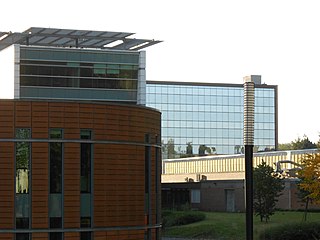
Français : Université Lille Nord de France- Campus Lille 1 - Cité scientifique - Bâtiments de l'École centrale de Lille et Polytech'Lille
English: University Lille Nord de France - Campus Lille 1 - Cité scientifique - Buildings of École centrale de Lille and Polytech'Lille
Deutsch: Universität Lille Nord de France (Nordfrankreich) - Campus Lille 1 - Cité scientifique - École centrale de Lille und Polytech'Lille
Español: Universidad de Lille Nord-de-France - Campus Lille 1 - Cité scientifique - Edificio École centrale de Lille y Polytech'Lille
Italiano: Université Lille Nord de France - Campus Lille 1 - Cité scientifique -Edificio École centrale de Lille e Polytech'Lille
Nederlands: Université Lille Nord de France - Campus Lille 1 - Cité scientifique - Gebouw École centrale de Lille en Polytech'Lille
Português: Université Lille Nord de France - Campus Lille 1 - Cité scientifique - Edifício École centrale de Lille e Polytech'Lille
Русский: Университет Лилля — Северной Франции - Campus Lille 1 - Cité scientifique - Здание École centrale de Lille и Polytech'Lille
|
| Date | |
| Source | Own work |
| Author | Frédéric Kuhlmann |
Licensing
I, the copyright holder of this work, hereby publish it under the following license:
This file is licensed under the Creative Commons Attribution-Share Alike 3.0 Unported license.
- You are free:
- to share – to copy, distribute and transmit the work
- to remix – to adapt the work
- Under the following conditions:
- attribution – You must give appropriate credit, provide a link to the license, and indicate if changes were made. You may do so in any reasonable manner, but not in any way that suggests the licensor endorses you or your use.
- share alike – If you remix, transform, or build upon the material, you must distribute your contributions under the same or compatible license as the original.
File history
Click on a date/time to view the file as it appeared at that time.
| Date/Time | Thumbnail | Dimensions | User | Comment | |
|---|---|---|---|---|---|
| current | 21:28, 15 September 2012 | | 4,608 × 3,456 (3.39 MB) | Frédéric Kuhlmann | User created page with UploadWizard |
File usage
The following pages on the English Wikipedia use this file (pages on other projects are not listed):
Global file usage
The following other wikis use this file:
- Usage on ar.wikipedia.org
- Usage on de.wikipedia.org
- Usage on fr.wikipedia.org
- Usage on ha.wikipedia.org
- Usage on nl.wikipedia.org
- Usage on ru.wikipedia.org
- Usage on sv.wikipedia.org
- Usage on tl.wikipedia.org
- Usage on www.wikidata.org
- Usage on zh.wikipedia.org