
File:China map green.png

Size of this preview: 800 × 588 pixels. Other resolutions: 320 × 235 pixels | 640 × 470 pixels | 1,024 × 753 pixels | 1,091 × 802 pixels.
Original file (1,091 × 802 pixels, file size: 133 KB, MIME type: image/png)
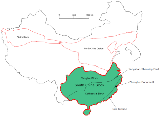
Summary[edit]
| Description |
location of South China Block marked in green |
|---|---|
| Source |
hand drawn on a computer by user:Makhkugeo Modified from Zheng, Y. F., Xiao, W. J., & Zhao, G. (2013). Introduction to tectonics of China. which can be seen here: [1] figure 2 on page 3. |
| Date |
2019 |
| Author |
Makhkugeo |
| Permission (Reusing this file) |
See below.
|
Licensing[edit]
I, the copyright holder of this work, hereby publish it under the following license:
| This work is licensed under the Creative Commons Attribution-ShareAlike 4.0 License. |
File history
Click on a date/time to view the file as it appeared at that time.
| Date/Time | Thumbnail | Dimensions | User | Comment | |
|---|---|---|---|---|---|
| current | 03:17, 23 November 2019 | | 1,091 × 802 (133 KB) | Makhkugeo (talk | contribs) | |
| 07:56, 3 November 2019 |  | 980 × 790 (65 KB) | Makhkugeo (talk | contribs) | ||
| 07:49, 3 November 2019 |  | 979 × 786 (62 KB) | Makhkugeo (talk | contribs) | Modified from Zheng, Y. F., Xiao, W. J., & Zhao, G. (2013). Introduction to tectonics of China. |
You cannot overwrite this file.
File usage
The following pages on the English Wikipedia use this file (pages on other projects are not listed):