
File:2020 07 26 mt-wilson049 (50170581841).jpg

Original file (3,401 × 5,102 pixels, file size: 6.12 MB, MIME type: image/jpeg)
| This is a file from the Wikimedia Commons. Information from its description page there is shown below. Commons is a freely licensed media file repository. You can help. |
.jpg)
Summary
| Description |
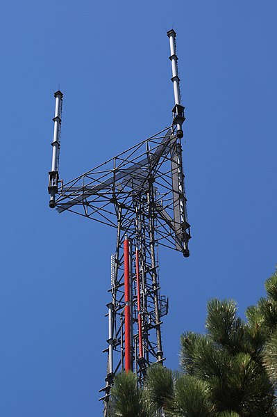
This is Antenna Structure Registration 1232157, better known as the Univision tower. Built here in the Mt. Alta section of Mt. Wilson in 2002, it is host to antennas for two TV stations: KMEX/34 and KFTR/46. There are no operating FM stations on this tower. Two of the three antennas atop the tower are KMEX's/ (The second is an auxiliary one.) The other is KFTR's main. The three look nearly identical, but have different specs, other than antenna height: 956 m (3136 ft.) above average terrain and 98 m (322 ft.) above ground and 1838.6 m (6032 ft.) above sea level. All three are also directional in a broad wilting-tulip shape toward the northeast, into the mountains. (Not sure why.) One of the four antennas on the side of the tower is KFTR's auxiliary antenna, for which it has a construction permit that expired in 2019. The others are not licensed or in use at this writing, in October 2020. I believe big red center-fed antenna is the one, because <a href="https://www.flickr.com/photos/infrastructure/50252324752/in/album-72157715576488368/">this photo from 2005</a> features two of the other three, one of which (the one that looks like vertebrae) is a low-power design. Mouse over for more. And be precise. The side-mounted antenna doesn't easily pop out. Details on the tower— Site location: 34-13-36.1 N 118-4-2.3 W (NAD 83) Site Elevation: 1740.6 meters (5711 ft) Height of Structure: 88.4 meters (290 feet) Overall Height Above Ground: 106.7 meters (350 feet) Overall Height Above Mean Sea Level: 1847.3 meters (6061 feet) |
| Date | |
| Source | 2020_07_26_mt-wilson049 |
| Author | Doc Searls |
Licensing
- You are free:
- to share – to copy, distribute and transmit the work
- to remix – to adapt the work
- Under the following conditions:
- attribution – You must give appropriate credit, provide a link to the license, and indicate if changes were made. You may do so in any reasonable manner, but not in any way that suggests the licensor endorses you or your use.
| This image was originally posted to Flickr by Nfrastructure at https://flickr.com/photos/46167543@N05/50170581841. It was reviewed on 6 November 2021 by FlickreviewR 2 and was confirmed to be licensed under the terms of the cc-by-2.0. |

|
This media file is uncategorized.
Please help improve this media file by adding it to one or more categories, so it may be associated with related media files (how?), and so that it can be more easily found.
Please notify the uploader with {{subst:Please link images|File:2020 07 26 mt-wilson049 (50170581841).jpg}} ~~~~ |
File history
Click on a date/time to view the file as it appeared at that time.
| Date/Time | Thumbnail | Dimensions | User | Comment | |
|---|---|---|---|---|---|
| current | 03:07, 6 November 2021 | | 3,401 × 5,102 (6.12 MB) | Sammi Brie | Transferred from Flickr via #flickr2commons |
.jpg)