
File:1246VOIVODATE.png

Size of this preview: 800 × 450 pixels. Other resolutions: 320 × 180 pixels | 640 × 360 pixels | 1,024 × 576 pixels | 1,280 × 720 pixels | 3,445 × 1,937 pixels.
Original file (3,445 × 1,937 pixels, file size: 525 KB, MIME type: image/png)
| This is a file from the Wikimedia Commons. Information from its description page there is shown below. Commons is a freely licensed media file repository. You can help. |
Summary
| Description |
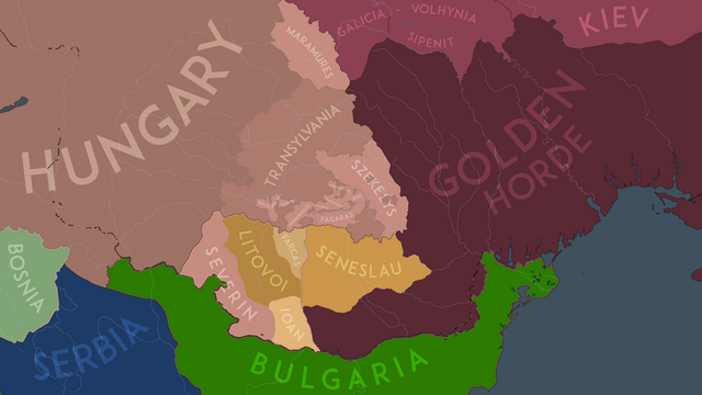
English: The political situation in the Carpathian Basin in the year 1246AD before the Diploma of the Joannites took effect. |
| Date | |
| Source | Own work |
| Author | NeimWiki |
Licensing
I, the copyright holder of this work, hereby publish it under the following license:
This file is licensed under the Creative Commons Attribution-Share Alike 4.0 International license.
- You are free:
- to share – to copy, distribute and transmit the work
- to remix – to adapt the work
- Under the following conditions:
- attribution – You must give appropriate credit, provide a link to the license, and indicate if changes were made. You may do so in any reasonable manner, but not in any way that suggests the licensor endorses you or your use.
- share alike – If you remix, transform, or build upon the material, you must distribute your contributions under the same or compatible license as the original.
File history
Click on a date/time to view the file as it appeared at that time.
| Date/Time | Thumbnail | Dimensions | User | Comment | |
|---|---|---|---|---|---|
| current | 18:44, 19 February 2024 | | 3,445 × 1,937 (525 KB) | NeimWiki | Changed Macso to be included in Hungary, since it was mentioned as Princess Margaret's domain (Bela III's daughter |
| 16:50, 11 August 2023 |  | 3,445 × 1,937 (527 KB) | NeimWiki | Changed the outline of autonomies. | |
| 17:40, 15 July 2023 |  | 3,445 × 1,937 (520 KB) | NeimWiki | Readded the de jure vassal outline of the Banate of Severin and its dependent Vlach knezates. | |
| 09:02, 4 June 2023 |  | 3,445 × 1,937 (514 KB) | NeimWiki | Redid the Wallachian northern border. | |
| 09:30, 19 April 2023 |  | 3,445 × 1,937 (520 KB) | NeimWiki | Updated Maramures. | |
| 15:29, 18 April 2023 |  | 3,445 × 1,937 (520 KB) | NeimWiki | Touched it up a bit. | |
| 15:44, 11 December 2022 |  | 3,445 × 1,937 (518 KB) | NeimWiki | Made the map more detailed. | |
| 15:04, 13 May 2022 |  | 3,445 × 1,937 (568 KB) | NeimWiki | Changed the name of the Mongols to Golden Horde. | |
| 14:52, 13 May 2022 |  | 3,445 × 1,937 (548 KB) | NeimWiki | A more accurate representation of the borders. | |
| 17:48, 3 September 2021 |  | 3,445 × 1,937 (542 KB) | NeimWiki | A more accurate representation of the borders and provinces. |
File usage
The following pages on the English Wikipedia use this file (pages on other projects are not listed):
Global file usage
The following other wikis use this file:
- Usage on mk.wikipedia.org
- Usage on ro.wikipedia.org