
Pambar River (Kerala)
| Pambar River | |
|---|---|
 | |
| Location | |
| Country | Idukki District, Kerala, India |
| Physical characteristics | |
| Source | |
| • location | Talaiyar at |
| • coordinates | 10°8′N 77°7′E / 10.133°N 77.117°E |
| • elevation | 2,073 metres (6,801 ft) |
| Mouth | |
• location | Amaravathi River at |
• coordinates | 10°21′2″N 77°14′14″E / 10.35056°N 77.23722°E |
• elevation | 473 metres (1,552 ft) |
| Length | ~31 kilometres (19 mi) |
Pambar River originates near Anamudi in Idukki district of Kerala state in South India.
Route[edit]
It traverses Turner's Valley in Eravikulam National Park and flows into the Chinnar Wildlife Sanctuary through the Taliar Valley between Kanthalloor and Marayoor Villages and eastwards through the sanctuary. The Pambar, Kabani and Bhavani are the only rivers of the 44 in Kerala that flow eastwards. It is joined by seasonal rivulets and a few perennial streams originating from sholas in the upper reaches.[1]
The Pambar merges with the Chinnar River at Koottar.[2] The Chinnar forms the interstate boundary along the northwest edge of the sanctuary and becomes the Amaravati River in Tamil Nadu, reaches the Amaravathi Reservoir and Dam and eventually joins the Kaveri River near Karur.[citation needed]
Waterfalls[edit]
The spectacular Thoovanam Waterfalls lie on the Pambar River deep within the Sanctuary. This breathtaking cascade is a major tourist attraction. Guided trekking from Karimutti Forest Station can be arranged.
-
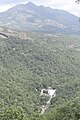
 Pambar River near SH 17
 -
 Thoovanam falls view from State Highway 17 in Kerala
 -
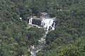 Zoom in view of Thoovanam falls


References[edit]
- ^ Kerala Forest department, Chinnar Wildlife Sanctuary, Management Plan (2002-2011) 2.5. Water sources Archived 2013-01-13 at archive.today
- ^ Blue Yonder Holidays Pvt Ltd, Chinnar, the real treasure trove, retrieved 8/30/2007 Koottar Tree House Archived 15 October 2008 at the Wayback Machine