
Nurpur kingdom
Mau-Paithan-Nurpur kingdom[1] | |||||||||||
|---|---|---|---|---|---|---|---|---|---|---|---|
| 1064–1815 | |||||||||||
| Capital | Pathankot (1064s–1580) Shahpurkandi (1650s–1781) Nurpur (1580s–1815) | ||||||||||
| Common languages | Takri script Dogri Kangri Chambeali Urdu | ||||||||||
| Religion | Hinduism | ||||||||||
| Government | Hereditary monarchy | ||||||||||
| Raja | |||||||||||
• 1064–1098 | Jhetpal (first) | ||||||||||
• 1805-1815 | Bhir Singh (last) | ||||||||||
| History | |||||||||||
• Established | 1064 | ||||||||||
• Disestablished | 1815 | ||||||||||
| |||||||||||
| History of India |
|---|
 |
| Timeline |
Nurpur kingdom in the Himalayan foothills of India was founded in 1064 A.D at north-eastern Bari Doab[2] between the Ravi and the Beas rivers at the fusion of Kangra, Duggar, Majha, Dharab and Chamba areas which ended in 1815. The remnants of Nurpur kingdom exist as ruined forts, restored temples, water bodies, and canals in Nurpur tehsil, Fatehpur tehsil, Pathankot tehsil, Dhar Kalan tehsil, Jawali tehsil, Indora tehsil Bhattiyat tehsil, and Sihunta tehsil.[3]

History[edit]
The Nurpur kingdom, originally known as Dhameri (धमेरी/دھمیری/ਧਮੇਰੀ), was founded towards the middle of the 11th century by Tomaras of Delhi.[4] Jhetpal the founder of Nurpur Kingdom in 1064 A.D was the younger brother of Anangpal II of Tomara dynasty from the family of King Arjuna of Mahabharata fame, 2250 years before him.[5][6] King Vikramaditya who began the Vikrama Samvat era in 57 BCE after defeating the Shakas belonged to the same lineage.[7] The principal era to which the luni-solar system is exclusively adapted is that of Vikramaditya, called Samvat. The prince from whom it was named was of the Tuár dynasty and is supposed to have reigned at Ujjain (Ujjáyini).
Tomar Raja Mahipal a k.a Kunwar Pāla (1021-1051) of Delhi in 1043 defeated Mahmud of Ghazni's grandson Mawdud of Ghazni and liberated the Nagarkot fort.[8] Mahmud of Ghazni's fifth son Abd al-Rashid (1049-1052) appointed Hastagin Hajib as the governor of Punjab and recaptured liberated Nagarkot fort in 1052 after the death of Raja Mahipal.[9] Late Raja Mahipal's brother Jhetpal Tomar led an expeditionary force to protect Trigarta king Jagdish Chand of Katoch dynasty and successfully recaptured the Kangra fort in 1060 AD.[10] In retaliation, Ibrahim of Ghazna (1059-1099) sent his son, Mahmud, with an army of ghazis consisting of 40,000 cavalry to raid Doab of Punjab region, between 1063 and 1070.[11] Due to these constant attacks Trigarta Kingdom shifted its capital from Doab Jalandhar to Kangra Fort in 1070 A.D. and to double secure Kangra Fort Jhetpal Tomar overpowered the garrison of Ghaznavid Kiladar Kuzbak Khan stationed at Paithan Fort, Pathankot which was the gateway to Kangra Valley between River Ravi and River Beas from the plains of Badi doab. Raja Jhetpal, after the death of Ibrahim of Ghazna in 1099 [12] permanently stationed his garrison at Pathankot and the territorial surname Pathania became surname of clan.[13][14]
Nurpur reached its peak between 1580 and 1613 during the reign of Raja Basu Dev who built an impressive fort that can still be seen today but his son Suraj Mal of Nurpur was driven away by Mughals in 1618.[15][16]
In 1620 the change of name from Dhameri to Nurpur was done by Raja Jagat Singh to honour Mughal emperor and empress as 'Nur' was a common prefix to their names Nur-ud-din Muhammad Jahangir and Nur Jahan.[17] Nurpur kingdom paid taxes after it came under Mughals. It rebelled when taxes were raised to 66% and the settlement took place after the War of Taragarh 1640–1642.
Till 1739 kingdom remained a feudatory state of Mughal Empire and became independent during Campaigns of Nader Shah. During Indian campaign of Ahmad Shah Durrani from (1747-1767) Raja Fateh Singh survived the invader but Raja Prithvi Singh (1770-1805) expelled Muslim branch of Pathania (1650-1781) based at Shahpurkandi Fort near Shahpurkandi dam project colony, they migrated to Pakistan in 1947. Also, Prithvi Singh forced his brother Inder Singh (Rey branch) whom he considered as claimant of Nurpur kingdom to take exile in 1779 at Mahal Moriyan Fort Kangra State (presently at Mehal Khas, Bhoranj, Hamirpur), they later migrated to Rey in 1823 after the death of Sansar Chand, Sikh Empire appointed Inder Singh's son Ishri Singh as courtier in the Lahore durbar and awarded Rey jagir. Ishri Singh was also brother-in-law of Dhian Singh, the longest reigning prime minister of Sikh Empire from 1818-1843.[18]
Raja Bhir Singh had to face threats from all sides bordering Sikhs, Gorkhas, Katoch and British. Ultimately after just 10 years of his reign Ranjit Singh the final winner of the contest annexed Nurpur kingdom in 1815.[19] Raja Bhir Singh retook the Nurpur in 1846 but died fighting at the gates of Nurpur Fort.[20]
His struggle was continued by his son Raja Jaswant Singh Pathania and his uncle's son 'Bansein Wazira' hi:राम सिंह पठानिया, who resorted to guerilla warfare but was captured by deceit from Lakhanpur, Jammu Fort by Jammu and Kashmir (princely state) which was under British control. The state was annexed by the British East India Company in 1849 and the last ruling monarch of Nurpur, was given Rs 5000/- financially compensated by the British for the loss of his state.[21]
Kings[edit]
The rulers of Nurpur bore the title 'Raja'.[22]

- c. 1095 Raja Jhet Pal
- 12th century – 1313 Uncertain number of successors
- 1313 – 1353 Jas Pal
- 1353 – 1397 Kailas Pal
- 1397 – 1438 Nag Pal
- 1438 – 1473 Prithi Pal
- 1473 – 1513 Bhil Pal
- 1513 – 1558 Bakht Mal
- 1558 – 1580 Pahari Mal
- 1580 – 1613 Basu Dev
- 1613 – 1618 Suraj Mal
- 1618 – 1646 Raja Jagat Singh
- 1646 – 1661 Rajrup Singh
- 1661 – 1700 Mandhata Singh
- 1700 – 1735 Dayadatha
- 1735 – 1770 Fateh Singh
- 1770 – 1805 Prithvi Singh
- 1805 – 1815 Bhir Singh
- 1846 – 1849 Jaswant Singh (state annexed by the British) (d. 1898)
Forts[edit]
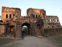
Nurpur (Dhameri) Fort[edit]
Fortified by Raja Vasudev after Pathankot was overtaken by Akbar in the 16th century. It was sacked in 1618 and 1640 by Mughals and remained the main seat of the royal family till 1849.
Taragarh Fort[edit]
This fortress was captured by Raja Jagat Singh Pathania from Chamba state and was secretly fortified by him and his sons in preparation for his infamous rebellion against Mughals(1640–42). This fort was never seized or captured.[23] However, Raja Jagat Singh Pathania was persuaded to stop the war against the Mughals. Shahjahan knew that Jagat Singh could not be browbeaten and he could use his help in times of war. Therefore, he sent for a compromise on mutually agreed terms.
The folklore associated with the siege of the fort goes that the Mughals forces cordoned off the fort for such a long time that they planted mango plants which fruited before the end of the siege (this place near taragarh fort today is called Amb ka Bagh literally meaning Mango orchard). Yet this long siege could not break the will of Raja jagat Singh and his men whose ration had diminished. According to folklore the men of Raja Jagat Singh one day to fool cordoning forces used the milk of female dog (who had been given litter inside fort but fed in Mughal camp) to prepare a kheer (milk pudding) and threw it outside the fort. When the cordon commander of Mughal forces saw this he died of shock and the news reached the Mughal emperor who was forced to negotiate with Raja Jagat Singh Pathania.
Pathan Fort[edit]
The very first fort after which the Pathania became a surname is now in ruins. Today, Fort Road and Gulmohar Resthouse exists on a top of a small hill at that very location.
Temples[edit]
Brijraj Mandir Nurpur Fort[edit]
It is the biggest shrine representing the Nurpur kingdom. The temple inside the fort called Brij Raj Swami was built in the 16th century and is known to be one of the only places where both the idols of Lord Krishna and Meera Bai are worshiped.
In Folklore[edit]
Legend of Brij Raj temple built in 1613, inside Nurpur Fort is a Krishna statue which lied in ruins of Fort Chittorgarh during Mughal occupation from (1568-1616). Raja Basu was sent to capture Rana of Mewar ( Udaipur) Amar Singh I where he died at thana Jhalawar in September 1613. His sons, especially Raja Suraj Mal of Nurpur must have accompanied Raja Basu although Raja Jagat Singh is reputed to have halted at Chittorgarh in the night and heard the sound of "ghungroo" and smell of Mollesary and someone reciting bhajan with "tanpura" outside in the ruins of Fort Chittor. When he told this episode to the learned Brahmin, he was advised by him that he had transcended into the twilight of Mira-Krishna and thus as a tribute to his enlightenment should smuggle the same very statue which Mira worshipped to hills where it will be safe from the barbaric hands of Mughals. The erected temple in Nurpur Fort closely resembles that of the Hari dev temple, built by Raja Bhagwant Das in Govardhan (1557), and of the Govind Dev Ji Temple shrine, erected by Mansingh in Sarii.Vrindavan (1590), as per ASI report, destruction of temple took place in (1618) when Suraj Mal of Nurpur rebelled. The frescoes in Diwan-i-Aam mentions the establishment year as (1610), while the statue was hidden underneath the pond during uncertain times. Thakur dwara was repaired and the statue was recovered in peaceful times by Raja Mandhatta (1661-1700) (grandson of Raja Jagat Singh). In 1886 ASI discovered the ruins of a temple which were excavated in 1904.[24]
The shrine was safely buried in the pond in 1618 when the Fort was besieged and there were no chances of survival by Raja Suraj Mal of Nurpur. The shrine came into the dreams of Raja Mandhata (1671-1700) who drained the pond and restored shrine's former glory.
Kali Mata Mandir Nurpur Fort[edit]
Patronized by Raja Jagat Singh who practiced his battlefield strategies by playing chauper (chess) with Devi. The temple seems to be rebuilt at the old location.
Raja ka Bagh[edit]
On the foots of Fort Mau, established at a 'bauli' (natural spring) to honour a snake born along with Raja Nag Pal in the 14th century. Descendants who believe their lineages from Nurpur kingdom offer the first hairs of their newly born sons.
Ratte Ghar Wali Mata[edit]
This temple is visible from some majorly parts of Nurpur, because it is located at high location. It is believed that this temple has the divine power, if someone pray for something then their wish is definitely fulfilled. For visiting this temple one should need go from a village named Baduhi, otherwise a backward road from Jassur town also keep you to this temple.
.jpg)
Gallery[edit]
-
 Exit of the Nurpur Fort
 -
 West view from Nurpur fort


See also[edit]
References[edit]
- ^ Charak, Sukhdev Singh (1978). History and Culture of Himalayan States Vol 1. Light and Life. ISBN 9780391011762. Retrieved 26 July 2021.
- ^ S.R Bakshi, Rashmi Pathak (2007). Punjab Through the Ages. Sarup & Sons. ISBN 978-81-7625-738-1.
- ^ Imperial Gazetteer of India, v. 19, p. 232.
- ^ Brentnall, Mark (2004). The Princely and Noble Families of the Former Indian Empire: Himachal Pradesh. Vol. 1. Indus Publishing. pp. 350–358. ISBN 978-8-17387-163-4.
- ^ Bakshi, Shiri Ram. Advanced History of Ancient India. p. 29.
- ^ Annals of Rajasthan Annals of Mewar: The Annals of Mewar By James Tod, Tod Payne C. H, C H Payne,Asian Educational Services,p39
- ^ Henry Thoby Prinsep, James Prinsep, Edward Thomas (1858). Essays on Indian Antiquities, Historic, Numismatic, and Palæographic, of the Late James Prinsep. J.Murray. p. 157.
{{cite book}}: CS1 maint: multiple names: authors list (link) - ^ "Medieval History of Himachal Pradesh". hpgeneralstudies. Retrieved 7 July 2022.
- ^ "History of Kangra Himachal Pradesh". Aim Success. Retrieved 20 August 2021.
- ^ Wink, André (1997). Al-Hind the Making of the Indo-Islamic World: The Slave Kings and the Islamic Conquests 11th-13th centuries. Vol. II. Brill. p. 134.
- ^ Wink, André (1997). Al-Hind the Making of the Indo-Islamic World: The Slave Kings and the Islamic Conquests 11th-13th centuries. Vol. II. Brill. p. 134.
- ^ Bosworth, C.E. (2007). "Ghaznavids". Encyclopedia Iranica. p. 81.
- ^ Singh, Mian Goverdhan (1999). Wooden Temples of Himachal Pradesh (1999 ed.). Indus Publishing. p. 34. ISBN 9788173870941.
- ^ Walia, A.N (2004). Chronology of Royal House of Pathania, Nurpur. Languages and Culture Department, Shimla H.P. p. 46.
- ^ "Ashmolean − Eastern Art Online, Yousef Jameel Centre for Islamic and Asian Art". Jameelcentre.ashmolean.org. 22 April 2012. Retrieved 24 August 2013.
- ^ Jerath, Ashok (2000). "2 - Forts on the left side of Ravi". Forts and Palaces of the Western Himalaya. New Delhi: M L Gidwani, Indus Publishing Company. p. 27. ISBN 9788173871047. Retrieved 28 March 2013.
- ^ "नूरजहां ने जलन के कारण इस किले में कटवा दी थी एक खूबसूरत नर्तकी की जीभ!". Navbharat Times. Retrieved 19 February 2022.
- ^ Walia, A N (2002). History of Pathania Rajas of Nurpur, District Kangra. Department of Language and Culture, Himachal Pradesh, Shimla-9. p. 60.
- ^ Walia, A N (2002). History of Pathania Rajas of Nurpur, District Kangra. Department of Language and Culture, Himachal Pradesh, Shimla-9. p. 55.
- ^ Macintyre, Ben (2002). The Man Who Would Be King: The First American in Afghanistan. Farrar, Straus and Giroux. p. 58. ISBN 978-0-374-20178-4.
- ^ "Wazir Ram Singh Pathania". Nag Mandir Jathare. Retrieved 19 February 2022.
- ^ "Indian Princely States K-Z". www.worldstatesmen.org. Retrieved 31 August 2019.
- ^ Dogra Legends of Art & Culture By Aśoka Jeratha, Ashok Jerath,Indus Publishing,p172,173
- ^ Page28-29 "ASI Report 1904 Report".
{{cite web}}: Check|url=value (help)
![]() Media related to Nurpur State at Wikimedia Commons
Media related to Nurpur State at Wikimedia Commons