
Khan Mean Chey
This article needs additional citations for verification. (December 2009) |
Mean Chey
ខណ្ឌមានជ័យ | |
|---|---|
 Mean Chey Skyline | |
 | |
 Mean Chey | |
| Coordinates: 11°31′14″N 104°54′53″E / 11.5206°N 104.9148°E | |
| Country | |
| Province | Phnom Penh |
| Area | |
| • Total | 29 km2 (11 sq mi) |
| Population (2019)[1] | |
| • Total | |
| Time zone | UTC+7 (Cambodia) |
| Geocode | 1206 |
Mean Chey (Khmer: មានជ័យ, Méanchei [miəncəj], lit. "Victorious") is an administrative district (khan) located in the south-eastern part of Phnom Penh, Cambodia. As of 2019, due to boundary changes, its population decreased from 2008 but is the second most populous district of Phnom Penh.[1]
Administration[edit]
According to the 1998 census, Mean Chey consisted of eight Sangkats with a total population of 157,112;[2] the population recorded by the 2008 census was 266,865.[3]
In 2010 Khan Mean Chey was expanded by incorporating four communes from Kien Svay District, Kandal Province: Kbal Kaoh, Preaek Aeng, Preaek Thmei and Veal Sbov.[4] In 2013, the latter four Sangkats, along with Chbar Ampov Ti Muoy, Chbar Ampov Ti Pir, Nirouth and Preaek Pra formed a new entity, Khan Chbar Ampov,[5][6] taking Mean Chey's number of Sangkats to four. In 2016, Stueng Mean Chey was split in three separate Sangkats and Boeng Tumpun was split in two parts.[5]
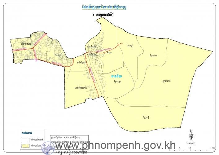
As of 2020, Mean Chey is subdivided into seven Sangkats (communes) and 59 Phums (villages).[5]
| Geocode | Sangkat (commune) | Phums (villages) |
|---|---|---|
| 120606 | Chak Angrae Leu | Prek Ta Kong, Prek Ta Nu, Prek Ta Kong I, Prek Ta Kong II, Prek Ta Kong III, Prek Ta Nu I, Prek Ta Nu II |
| 120607 | Chak Angrae Kraom | Tuol Roka, Prek Ta Long, Tuol Roka I, Tuol Roka II, Tuol Roka III, Prek Ta Long I, Prek Ta Long II, Prek Ta Long III |
| 120608 | Stueng Mean Chey 1 | Mean Chey, Mean Chey I, Mean Chey II, Thmei, Trea, Trea I, Trea II, Trea III |
| 120609 | Stueng Mean Chey 2 | Phneat, Damnak Thum, Damnak Thum I, Damnak Thum IV, Ruessei, Ruessei III, Prek Toal, Prek Toal I |
| 120610 | Stueng Mean Chey 3 | Trea IV, Ruessei I, Ruessei II, Damnak Thum II, Damnak Thum III, Damnak Thum V |
| 120611 | Boeng Tumpun 1 | Chamraeun Phal, Chamraeun Phal I, Chamraeun Phal II, Chamraeun Phal III, Chamraeun Phal IV, Sansam Kosal I, Sansam Kosal II, Sansam Kosal III, Sansam Kosal IV, Sansam Kosal V, Sansam Kosal VI |
| 120612 | Boeng Tumpun 2 | Kbal Tumnob, Kbal Tumnob I, Kbal Tumnob II, Kbal Tumnob III, Tnaot Chrum, Tnaot Chrum I, Tnaot Chrum II, Tnaot Chrum III, Tnaot Chrum IV, Tnaot Chrum V, Tnaot Chrum VI |
Education[edit]
Since 2015 the campus of the International School of Phnom Penh (ISPP) is on Hun Neang Boulevard,[7] in Mean Chey Section.[8]
Home of English International School Prek Eng Branch is in Mean Chey Section.[9][8]
National Institute of Business (NIB) is located Next to New Steung Mean Chey Market on Street 217 in Mean Chey Section.[10] It was established in 1979. [11]
Buddhist temples[edit]
List of pagodas in Khan Mean Chey[12]
- Wat Changkran Ta Prohm Steung Meanchey (Wat Steung Meanchey)
- Wat Sansam Kosal
- Wat Dombok Khpuos
- Wat Chak Angre Leu
- Wat Chak Angre Krom
- Wat Ang Porthi Nhean
- Wat Noun Mony
- Wat Samaki Raingsey
Gallery[edit]
-
 Mean Chey Skyline
 -
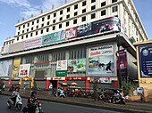
 Veng Sreng Boulevard at Steung Mean Chey Junction
 -
 Aerial View of New Steung Mean Chey Market
 -
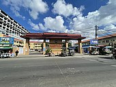
 New Steung Mean Chey Market in 2022
 -
 Steung Mean Chey Market
 -
 New Steung Mean Chey Market
 -
 Wat Dombok Khpuos
 -
 Aerial View of Wat Noun Mony
 -
 Mean Chey District Hall
 -
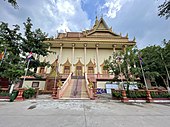
 Temple of Wat Steung Mean Chey
 -
 National Institute of Business (NIB)
 -
 Wat Sansam Kosal


.jpg)


.jpg)
.jpg)

References[edit]
- ^ a b "General Population Census of the Kingdom of Cambodia 2019 – Final Results" (PDF). National Institute of Statistics. Ministry of Planning. 26 January 2021. Retrieved 3 February 2021.
- ^ "General Population Census of Cambodia 1998, Final Census Results" (PDF). National Institute of Statistics, Ministry of Planning, Cambodia. August 2002. p. 174. Retrieved 9 June 2020.
- ^ "2008 Census – Mean Chey District". opendevelopmentcambodia.net. Open Development Cambodia. Retrieved 9 June 2020.
- ^ "Administrative Area Changes of Phnom Penh Municipality on 5 November 2010" (PDF). stat.go.jp. Statistics Bureau of Japan. Retrieved 9 June 2020.
- ^ a b c "Cambodia Gazetteer Database Online". National Committee for Sub-National Democratic Development. Retrieved 9 June 2020.
- ^ Khuon Narim (18 December 2013). "Three New Districts in Phnom Penh Approved". The Cambodia Daily. Retrieved 9 June 2020.
- ^ "ISPP_on_the_map_July_2015.pdf" (PDF). International School of Phnom Penh. Retrieved 2020-05-14.
International School of Phnom Penh Secondary Campus Hun Neang Boulevard, Phnom Penh, Cambodia
- ^ a b "Property Tax Map". City of Phnom Penh. Retrieved 2020-05-06. - Map of Mean Chey Section - Compare map to Google Maps view of Mean Chey District and Map from the Japanese Government Statistics Agency.
- ^ "Contact Us". Home of English International School. Retrieved 2020-05-16.
Prek Eng Branch National Road #1, Phnom Penh, Cambodia
- ^ "ប្រវត្តិវិទ្យាស្ថានជាតិពាណិជ្ជសាស្រ្ត".
- ^ "National Institute of Business in Cambodia".
- ^ "All Pagodas in Phnom Penh". kampucheathmey.com. Kampuchea Thmey. Retrieved October 1, 2021.
| Autonomous municipality |
| ||
|---|---|---|---|
| Provinces | |||
| International | |
|---|---|
| National | |
This Cambodian location article is a stub. You can help Wikipedia by expanding it. |