Młynary
Młynary | |
|---|---|
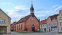
 Immaculate Conception church in Młynary | |
| Coordinates: 54°11′14″N 19°43′45″E / 54.18722°N 19.72917°E | |
| Country | |
| Voivodeship | Warmian-Masurian |
| County | Elbląg |
| Gmina | Młynary |
| Established | 14th century |
| Area | |
| • Total | 2.76 km2 (1.07 sq mi) |
| Elevation | 53 m (174 ft) |
| Population (2018) | |
| • Total | 1,782[1] |
| Time zone | UTC+1 (CET) |
| • Summer (DST) | UTC+2 (CEST) |
| Postal code | 14-420 |
| Vehicle registration | NEB |
| Voivodeship roads | |
| Website | www.mlynary.pl |
Młynary [mwɨˈnarɨ] (German: Mühlhausen in Ostpreußen) is a town in northern Poland, in Elbląg County, Warmian-Masurian Voivodeship, with 1,782 inhabitants (2018). This makes it the smallest of the 49 towns in the voivodeship.
History[edit]

The town was founded in the 14th century. A document from 1338 specifies the rules of judicial settlement of potential disputes between people of the town's three main ethnic groups: Poles, Old Prussians and Germans.[2]
In 1440, the town joined the anti-Teutonic Prussian Confederation, at the request of which King Casimir IV Jagiellon signed the act of incorporation of the region to the Kingdom of Poland in 1454,[3] an event that sparked the Thirteen Years’ War (1454–1466). In 1455 the town was briefly captured by the Teutonic Knights and the town's mayor was drowned by them in retaliation. After the peace treaty signed in Toruń in 1466, the town became a part of Poland as a fief held by the Teutonic Knights.[4]
In 1628 the town was captured and occupied by the Swedes.[5] In 1773, a year after the First Partition of Poland, the 52nd Fusilier Regiment of Prussia was located in the town. During the Napoleonic Wars, in 1807 French troops entered the town and stayed over a year.[5] In November 1831, several Polish infantry units and honor guards of the November Uprising stopped near the town on the way to their internment places.[6]
Between 1871 and 1945 the area was part of Germany (province of East Prussia). After World War II the region became again part of Poland by the Potsdam Agreement under territorial changes demanded by the Soviet Union.
Historic Polish names of the town, other than Młynary, were also Młyny and Miluza.[2]
Transport[edit]
Młynary is located at the intersection of the Voivodeship roads 505 and 509, and the Polish Expressway S22 runs nearby, northwest of the town.
Sports[edit]
The local football club is Syrena Młynary.[7] It competes in the lower leagues.
Notable people[edit]
- Maciej Płażyński, Polish politician
References[edit]
- ^ "Młynary, Polska w Liczbach, GUS". Retrieved June 8, 2019.
- ^ a b Słownik geograficzny Królestwa Polskiego i innych krajów słowiańskich, Tom VI (in Polish). Warszawa. 1885. p. 539.
{{cite book}}: CS1 maint: location missing publisher (link) - ^ Górski, Karol (1949). Związek Pruski i poddanie się Prus Polsce: zbiór tekstów źródłowych (in Polish). Poznań: Instytut Zachodni. pp. XXXVII, 54.
- ^ Górski, pp. 96–97, 214–215
- ^ a b "Historia, Miasto i Gmina Młynary". Retrieved June 8, 2019.
- ^ Kasparek, Norbert (2014). "Żołnierze polscy w Prusach po upadku powstania listopadowego. Powroty do kraju i wyjazdy na emigrację". In Katafiasz, Tomasz (ed.). Na tułaczym szlaku... Powstańcy Listopadowi na Pomorzu (in Polish). Koszalin: Muzeum w Koszalinie, Archiwum Państwowe w Koszalinie. p. 140.
- ^ "Strona internetowa klubu Syrena Młynary" (in Polish). Retrieved 23 October 2021.


