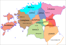
Mõhu
| Mõhu | |||||||
|---|---|---|---|---|---|---|---|
| county of Ancient Estonia | |||||||
| 9th Century–1224 | |||||||
 Ancient Estonian counties | |||||||
| Area | |||||||
| • Coordinates | 58°40′N 26°00′E / 58.67°N 26°E | ||||||
| History | |||||||
• Established | 9th Century | ||||||
• Livonian Crusade | 1224 | ||||||
| |||||||
Mõhu was a small landlocked ancient Estonian county in the central part of the territory of Estonia. It was later conquered by the Teutonic Order during the Estonian Crusade.[1]
See also[edit]
References[edit]
- ^ "Mõhu - Eesti Entsüklopeedia". entsyklopeedia.ee. Retrieved 18 January 2022.
