
Lydford
| Lydford | |
|---|---|
 St Petrock's Church, Lydford | |
 Lydford Location within Devon | |
| Population | 394 (2001 Census) |
| OS grid reference | SX512850 |
| District | |
| Shire county | |
| Region | |
| Country | England |
| Sovereign state | United Kingdom |
| Post town | Okehampton |
| Postcode district | EX20 |
| Police | Devon and Cornwall |
| Fire | Devon and Somerset |
| Ambulance | South Western |
| UK Parliament | |
Lydford, sometimes spelled Lidford, is a village, once an important town, in Devon, seven miles (11 km) north of Tavistock[1] on the western fringe of Dartmoor in the West Devon district. There is an electoral ward with the same name which includes Princetown. The population of this ward at the 2011 census was 2,047.[2]
Description[edit]
The village has a population of 458.[3] The village stands on the small River Lyd, which traverses a deep narrow chasm, crossed by a bridge of single span; and at a little distance a tributary stream forms a cascade in an exquisite glen.
The village is noted for its history and surrounding countryside and is popular with tourists. From its Perpendicular church of St Petrock fine views of the Dartmoor tors are seen. The parish of Lydford is immense, embracing some 50,000 acres (200 km2) of land. Close to the church are slight remains of the castle of Lydford.
Running south-west from the village is Lydford Gorge, a 1.5-mile (2.4-km) wooded gorge which has been cut through the slate rock by the River Lyd. The gorge area is owned by the National Trust.[4] The gorge is noted for its 30-metre (100 ft) waterfall.
Etymology[edit]
The original Anglo-Saxon names for the village were Hlidaford or Hlidan, from hlid, meaning a cover or lid, referring to the almost perfect concealment of the river beneath the chasm at the bridge, and ford (crossing). Over the years the name mutated via Lyghatford, Lidefort and Lideford to the contemporary spelling.
History[edit]

Historically Lydford was an economic powerhouse, not the peaceful village it is today.
The village was established as one of the four Saxon burhs of Devon by king Alfred the Great. It first appears in recorded history in 997, when the Danes made a plundering expedition up the Tamar and Tavy as far as Hlidaforda (i.e. Lydford). The attack is described in the following passage from the Anglo-Saxon Chronicle:
- Her on ðissum geare ferde se here abutan Defenanscire into Sæfern muðan and þær heregodan ægðer ge on Cornwealum and on Norðwealum and on Defenum, and eodon him þa up æt Wecedport and þær micel yfel worhton on bærnette and on mannslihtum, and æfter þam wendon eft abutan Penwiðsteort on þa suðhealfe and wendon þa into Tamer muðan and eodon þa up oð hi comon to Hlydanforda, and ælc þing bærndon and slogon þe hi gemitton, and Ordulfes mynster Tæfingstoc forbærndon and unasecgendlice herehyðe mid him to scypon brohton.
- Translation: In this year, they (the Vikings) visited Devonshire and at the mouth of the Severn, pillaging in Cornwall, Devon and Wales. They went to Watchet, and there caused much damage by dint of arson and wholesale slaughter. Then they turned at Penwith Tail to the south and up into the mouth of the Tamar, travelling to Lydford, burning and slaughtering anything they came across, and burned down Ordwulf's monastery at Tavistock, carrying vast amounts of loot back to their ships.
During the reign of Ethelred the Unready there was a mint; coins minted there were inscribed LVD., LVDA, and LVDAN. In the reign of Edward the Confessor it was the most populous centre in Devonshire after Exeter, but Domesday Book relates that forty houses had lain waste since the Conquest. The town never recovered its former prosperity under the Normans and, according to Domesday Book, Lydford was taxed equally with London, giving us an idea of its significance at the time. The reason is that under the Normans, the parish of Lydford included all of the Forest of Dartmoor (as it did until the 20th century).
Until the 12th century parishioners from across most of Dartmoor were brought to Lydford for burial. The path used to make this final journey is known as the 'Lych way'. Many reports have been made of monks in white and phantom funeral processions seen walking along this path.[5]
The history from the 13th century centres on the castle. The castle is first mentioned in 1216, when it was granted to William Briwere, and was shortly afterwards fixed as the prison of the stannaries and the meeting-place of the Forest Courts of Dartmoor. A gild at Lideford is mentioned in 1180, and the pipe roll of 1195 records a grant for the reestablishment of the market. In 1238 the borough, which had hitherto been crown demesne, was bestowed by Henry III on Richard, earl of Cornwall, who in 1268 obtained a grant of a Wednesday market and a three days fair at the feast of St Petrock. The borough had a separate coroner and bailiff in 1275, but it was never incorporated by charter, and only once, in 1300, returned members to parliament.
During the English Civil War, Lydford was the haunt of the then notorious Gubbins band, a gang of ruthless cut-throats and highwaymen, who took advantage of the turmoil of the times to ply their villainry. According to one account of the time:
- Gubbins-land is a Scythia within England, and they pure heathens therein. Their language is the drosse of the dregs of the vulgar Devonian, They hold together like burrs: offend one and all will avenge their quarrel.
In 1987 the parish of Lydford finally lost its claim to be the largest parish in England. It was split into two civil parishes, Lydford and Dartmoor Forest.[6] The ecclesiastical parish has also been split, with Princetown made a separate parish.[7]
Lydford Church[edit]

The dedication of the parish church to St. Petrock would seem to indicate that it was built on the site of a pre-existing British settlement.
The current church was built in the perpendicular gothic style, and although ostensibly Norman, some of the architectural furniture, for example the font, is of the Anglo-Saxon style (or at latest, early Norman), thus it would appear that the church was rebuilt upon the site of the earlier building.
The church was enlarged in the 13th century, the tower being added in the 15th century. A further enlargement occurred c. 1890 with the addition of the vestry and northern aisle.
Lydford Castle[edit]
Two castles have been built at Lydford, the first immediately in the wake of the Norman Conquest in 1066.
The second castle was built on the site of the first castle in c. 1132 AD. It was a 3-storey tower, commanding a strategic view over much of the surrounding countryside, and was eminently defensible, with Lydford Gorge on one side, and the land sloping steeply away from it.
Its use changed under the aegis of Edward I of England who made the castle the Stannary prison; its reputation was not good. Sir Richard Grenville used the prison as an oubliette for his political opponents. An order of Parliament during the reign of Henry VIII describes the prison in 1512 as "one of the most hanious, contagious and detestable places in the realm"; Lydford Law was a by-word for injustice. It was also one of the seats of the Bloody Assizes of Hanging Judge Jeffreys.
The prison is commemorated in the poem Lydford Law by the Tavistock poet William Browne:
I've often hear of Lydford law,
How in the morn they hang and draw,
And sit in judgement after
At the time of Cromwell's Commonwealth, the castle was entirely in ruins, but in the 18th century it was restored and again used as a prison and as the meeting-place of the manor and borough courts. The site is now maintained by English Heritage,[8] and entry is free of charge.
Lydford's toll road[edit]
Lydford is located on the former stage-coach route between Tavistock and Okehampton, now the A386. On this old toll road near Beardon is a 'Take-off' stone set in the verge. On steep hills heavily laden waggons or coaches could add an extra toll-free horse to help pull the vehicle up the hill, but this horse had to be taken off at the top. Very few of these stones still exist in situ.[9]
Lydford's railway stations Gallery[edit]
-
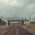 Lydford's former London & South Western Railway station (LSWR) on 16 November 1969. The line to Exeter via Tavistock had opened on 14 October 1874 and closed in 1968. The track was being lifted on the day this photograph was taken.
 -
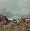 The Great Western Railway (GWR) part of the joint station with the LSWR was taken on 16 November 1969. The station had opened in 1865 and closed in 1966.
 -
 The junction between the LSWR and GWR lines.


Lydford Foxes[edit]
In 2016, the Lydford Foxes youth football club was established, becoming affiliated with the Devon FA and members of the Devon Junior & Minor League in 2017. The majority of players live in the village, along with surrounding towns and villages, such as Okehampton, Mary Tavy, Lewdown, Sourton and Bridestowe, with home matches played in Lydford and Mary Tavy.
In July 2019, the club was named Grassroots Club of the Year - Runner Up at the Devon FA Grassroots Football Awards.
Twin towns[edit]
Lydford is twinned with Petiville, France.
References[edit]
- ^ Wilson, John Marius. "Imperial Gazetteer of England and Wales (1870–72)". Retrieved 29 March 2011.
- ^ "Ward population 2011". Retrieved 17 February 2015.
- ^ Devon County Council, 2001. "West Devon parish population estimates Archived 22 March 2005 at the Wayback Machine."
- ^ National Trust, 2004. "Lydford Gorge."
- ^ Hippisley Coxe, Anthony E. (1973). Haunted Britain. Hutchinson. p. 30. ISBN 0-09-116540-7.
- ^ Lydford Parish Council website
- ^ Diocese of Exeter: parish profile, Princetown Archived 29 June 2008 at the Wayback Machine
- ^ Palmer, D.W., 2004. "Lydford Castle Archived 7 November 2005 at the Wayback Machine."
- ^ Minchinton, Walter, 1974. Devon at Work : Past & Present. Pub. David & Charles. P. 77.
Sources and external links[edit]
- This article incorporates text from a publication now in the public domain: Chisholm, Hugh, ed. (1911). "Lydford". Encyclopædia Britannica (11th ed.). Cambridge University Press.
- Lydford Parish Council and village website
- Lydford village website
- Lydford Foxes AFC website
- St Petroc's Church, Lydford website - for information on church services, booking weddings and baptisms, church history and genealogy searches
- Lydford Castle and Saxon Town - official site at English Heritage
 Lydford travel guide from Wikivoyage
| International | |
|---|---|
| National | |