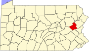
Junedale, Pennsylvania
Junedale, Pennsylvania | |
|---|---|
Unincorporated community | |
| Coordinates: 40°55′24″N 75°56′30″W / 40.92333°N 75.94167°W | |
| Country | United States |
| State | Pennsylvania |
| County | Carbon |
| Township | Banks |
| Elevation | 1,670 ft (510 m) |
| Time zone | UTC-5 (Eastern (EST)) |
| • Summer (DST) | UTC-4 (EDT) |
| ZIP code | 18230 |
| Area code(s) | 570 and 272 |
| GNIS feature ID | 1178192[1] |
Junedale is an unincorporated community located in Banks Township in Carbon County, Pennsylvania, United States. Junedale is part of the Lehigh Valley, which has a population of 861,899 and is the 68th most populated metropolitan area in the U.S. as of the 2020 census.
Junedale is located along Main Street west of Beaver Meadows and east of Tresckow.[2]
References[edit]
- ^ "Junedale". Geographic Names Information System. United States Geological Survey, United States Department of the Interior.
- ^ Carbon County, Pennsylvania Highway Map (PDF) (Map). PennDOT. 2016. Retrieved June 19, 2017.


