
János-hegy
János Hill
János-hegy | |
|---|---|
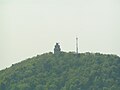
 View of János Hill from Kis-Hárs Hill | |
| Etymology: John's Hill | |
 | |
| Coordinates: 47°31′06″N 18°57′33″E / 47.518333°N 18.959167°E | |
| Country | |
| City | Budapest |
János Hill (Hungarian: János-hegy) (also John's Hill) is the highest point of Budapest with a height of 528 m (1,732 ft), located in the western part of the city. From Elizabeth Lookout on the top of the hill one can get an impressive panoramic view of the whole region.
Background[edit]
János-hegy belongs to Buda Hills and it is connected to the popular tourist sight Normafa. Between the two hills spread the long and narrow Normafa Plateau (Normafa fennsík). The top of the hill can also be accessed by the Libegő, a chairlift which connects it with Zugliget. The hill is made up of Dachstein Formation.
In the János-hegy area you will find the Budakeszi Game Preserve[1]
In the saddle between Hárshegy and János-hegy is Szépjuhászné the site of the Pauline Monastery where the Pauline Order founded their first friary.[2]
Gallery[edit]
-
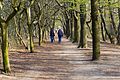 Nature on the hill
 -
-
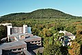 View from the Europa Congress Center to the János-hegy
 -
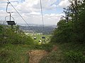 The popular Libegő
 -
 View from József-hegy lookout tower


References[edit]
- ^ "This is why they call Buda the hilly side". Budapest Times. Archived from the original on 2016-04-11. Retrieved 2016-03-29.
- ^ Vegh, Andras (2016). Nagy, Balazs (ed.). Buda-Pest 1300 - Buda-Pest 1400. Two Topographical Snapshots. Leiden: Brill. p. 187. ISBN 978-90-04-30768-1. LCCN 2016014148.
{{cite book}}:|work=ignored (help)
External links[edit]
- "Go Beyond in Budapest: János Hill's Erzsébet Lookout Tower".
- "Elizabeth Lookout Tower".
- "János Hill lookout Tower, Chairlift".
- "The Best Walking Trails in Budapest".
- "Budapest Chairlift: Libego on Janoshegy".
This Budapest location article is a stub. You can help Wikipedia by expanding it. |