
Italian concession of Tianjin
Italian concession of Tianjin | |||||||||
|---|---|---|---|---|---|---|---|---|---|
| 1901–1943 | |||||||||
_crowned.svg) Flag | |||||||||
| Status | Concession of the Kingdom of Italy | ||||||||
| History | |||||||||
• Established | 1901 | ||||||||
• Annexation | 1943 | ||||||||
| |||||||||

The Italian concession of Tianjin (Chinese: 天津意租界; pinyin: Tiānjīn Yì Zūjiè, Italian: Concessione italiana di Tientsin) was a small territory (concession) in central Tianjin (formerly romanized as Tientsin), China, controlled by the Kingdom of Italy between 1901 and 1943, officially ceded to China in 1947.
Characteristics[edit]

On 7 September 1901, Italy was granted a concession of 46 hectares (114 acres) in Tientsin from the Chinese government. On 7 June 1902, the Italians took control of the concession, which was to be administered by an Italian consul. The Italian Regia Marina ("Royal Navy") stationed vessels at Tientsin such as the river gunboats Ermanno Carlotto and Sebastiano Caboto.[1]
In 1917, during World War I, the Republic of China terminated both the German Empire's lease of the German concession of Tianjin and Austria-Hungary's lease of the Austro-Hungarian concession of Tianjin. The two districts were converted into "Special Areas" under Chinese control, with a separate administration from the rest of Tientsin.
The Italian concession became the headquarters of the Italian Legione Redenta that fought in 1919 during the Allied intervention against Red Army troops in Siberia and Manchuria during the Russian Civil War. After the end of World War I, Italy requested control of the Second Special Area (the territory of the former Austro-Hungarian concession) and obtained it in 1920,[2] which doubled the size of the Italian concession. Italy returned the Second Special Area to the Chinese authorities when it was in danger of coming under attack and occupation during the Chinese Civil War.[3]
In 1935, the Italian concession had a population of about 6,261, including 110 Italian civilians and about 536 foreigners. It was the refuge of many rich Chinese families escaping from Japanese forces after the Second Sino-Japanese War began in 1937.[4]
History[edit]


During the Boxer Rebellion in 1900, the Beijing Legation Quarter became the center of an international incident during the Siege of the International Legations by the Boxers for several months. After the siege had been broken by the Eight-Nation Alliance (that included Italy) at the end of the Battle of Peking, the foreign powers obtained the right to station troops to protect their legations under the terms of the Boxer Protocol. In addition, Italy obtained the concession in Tientsin, southeast of Beijing.
On 7 September 1901, a concession in Tientsin was ceded to the Kingdom of Italy by the Qing dynasty of China. On 7 June 1902, the concession was taken into Italian possession and administered by an Italian consul: the first was Cesare Poma and the last (in 1943) was Ferruccio Stefanelli.
Along with the other foreign concessions, the Italian concession lay on the Pei Ho, southeast of the city centre.
In the late 1920s, the Italians even held small forts such as the Forte di Shan Hai Kuan near the Great Wall of China in Manchuria[5] and in Hankow.
In 1925, Benito Mussolini created the Battaglione italiano in Cina and quartered it with soldiers of the San Marco Regiment in the new Caserma Ermanno Carlotto.[6] The police were Chinese, while the officers were Italians. There was even a football team in the Italian concession.[7]
During World War II, the Italian concession in Tientsin had a garrison of approximately 600 Italian troops.[citation needed] On 9 September 1943, after the publication of the Italian armistice with the Allies, the concession was occupied by the Imperial Japanese Army without fighting and the Italians were interned at Tangshan. In November, they were given the choice to give their allegiance to Mussolini's new Italian Social Republic. Those that did had their personal weapons returned and were used by the Japanese as labour troops.[8]
In July 1944, the Italian Social Republic formally relinquished the concession to Wang Jingwei's Japanese-sponsored Reorganized National Government of China which, like the RSI in Axis-held northern Italy, was not recognized by the Kingdom of Italy, the Republic of China, or most other nations.[9] The Wang Jingwei government fell when the Empire of Japan was defeated. At the same time, the Italian commercial concessions in the Shanghai International Settlement, Hankou, and Beijing were ceded to the Republic of China.[citation needed]
On 2 June 1946, the Kingdom of Italy became the Italian Republic and, on 10 February 1947, by virtue of the peace treaty with the Allied powers, the Italian concession was formally ceded by Italy to Chiang Kai-shek's Republic of China.[citation needed]
Governors[edit]
During the Italian presence, the following governors succeeded each other:[10]
- Cesare Poma (1901–1903)
- Giuseppe Chiostri (1904–1906)
- Oreste Da Vella (1906–1911)
- Vincenzo Fileti (1912–1920)
- Marcello Roddolo (1920–1921)
- Luigi Gabrielli di Quercita (1921–1924)
- Guido Segre (1925–1927)
- Luigi Neyrone (1927–1932)
- Filippo Zappi (1932–1938)
- Ferruccio Stefenelli (1938–1943)
-
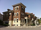
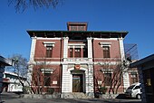 The Italian consulate, built in 1916
 -
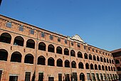 Italian barracks, built in 1916
 -
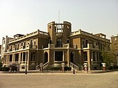
 Former residence of Cao Kun
 -
 North China Conservancy Commission
 -
 Sacred Heart Church, built in 1922
 -
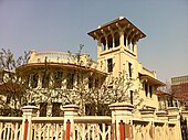 A mansion near Piazza Regina Elena
 -
 A mansion, former residence of Liang Qichao
 -
 Italian Theatre in Hebei District, Tianjin


See also[edit]
- Concessions in Tianjin
- Concessions of Italy in China
- Map of concessions in Tianjin (in Chinese)
- Italian Empire
- List of former foreign enclaves in China
Notes[edit]
- ^ Marinelli, M.; Andornino, G. (2013-11-07). Guido Samarani: "The Italian presence in China", p. 54. ISBN 9781137290939. Retrieved 23 November 2014.
- ^ AA VV (21 September 2012). "Restituiamo la Storia" – dagli archivi ai territori: Architetture e modelli urbani nel Mediterraneo orientale. ISBN 9788849273649.
- ^ "Italian occupation of former Austrian Concession". Retrieved 23 November 2014.
- ^ Grasselli, Enrico. "L’esercito italiano in Francia e in Oriente" p. 370-371
- ^ Trentoincina. "Italian Fort near the "China Great wall" (in Italian)". Retrieved 23 November 2014.
- ^ Caserma Carlotto photo
- ^ Trentoincina. "Football team". Retrieved 23 November 2014.
- ^ Enrico Cernuschi and Vincent P. O'Hara (2006), "Italy and the Pacific War", World War II Quarterly 3(1): 14–19.
- ^ Guido Samarani (2010), "An Historical Turning Point: Italy's Relations with China Before and After 8 September 1943", Journal of Modern Italian Studies 15(4): 590–602.
- ^ Beltrami, Vanni (2011). Italia d'oltremare: Storie dei territori italiani dalla conquista alla caduta. ISBN 9788861347021.
Bibliography[edit]
- Cucchi, Giuseppe. Una bandiera italiana in Cina, Rivista Militare, n. 6/1986.
- De Courten, Ludovica, Sargeri, Giovanni. Le Regie truppe in Estremo Oriente, 1900-1901. Ufficio Storico Stato Maggiore dell’Esercito, Roma, 2005.
- Dikötter, Frank. The Age of Openness China before Mao University of Chicago Press. Berkeley, 2008 ISBN 9780520258815.
- Donati, Sabina. Italy’s Informal Imperialism in Tianjin during the Liberal Epoch, 1902-1922, The Historical Journal, Cambridge University Press, 2016, available on CJO2016, doi:10.1017/S0018246X15000461.
- Grasselli, Enrico. L’esercito italiano in Francia e in Oriente Corbaccio ed. Milano, 1934.
- Marinelli, Maurizio, Andornino, Giovanni. Italy's Encounter with Modern China: Imperial dreams, strategic ambitions, New York: Palgrave Macmillan, 2014.
- Marinelli, Maurizio. “The Triumph of the Uncanny: Italians and Italian Architecture in Tianjin”, In Cultural Studies Review, Vol. 19, 2, 2013, 70–98.
- Marinelli, Maurizio. “The Genesis of the Italian Concession in Tianjin: A Combination of Wishful Thinking and Realpolitik”. Journal of Modern Italian Studies, 15 (4), 2010: 536–556.
- Mautone, Antonio. Trentini ed Italiani contro l'Armata Rossa. La storia del corpo di spedizione in Estremo Oriente e dei Battaglioni Neri. Temi editrice. Trento, 2003.
