
Georgia Veterans State Park
| Georgia Veterans State Park | |
|---|---|
 Georgia Veterans State Park entrance | |
 | |
| Location | Crisp County, Georgia |
| Nearest city | Cordele, Georgia |
| Coordinates | 31°57′23″N 83°54′58″W / 31.95639°N 83.91611°W |
| Area | 1,308 acres (530 ha) |
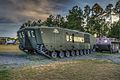
Georgia Veterans State Park (originally the Georgia Veterans Memorial State Park) is a state park located on Lake Blackshear in Crisp County, west of Cordele, Georgia. It was established on December 4, 1946, as a memorial to U.S. Veterans. The 1,308-acre (5 km2) park features a museum with aircraft, vehicles, weapons, uniforms and other memorabilia dating from the Revolutionary War to the present.
Other attractions include 8,600-acre (35 km2) Lake Blackshear, a privately operated conference center and golf club and the SAM Shortline Excursion Train, which runs from Cordele to Plains.
In 2013, Georgia Veterans State Park was privatized and its management handed over to Coral Hospitality, a Florida-based hotel and resort management company.[1]
Facilities[edit]
- 82 campsites with cable TV hookups for tents, trailers or RVs
- Pioneer campground
- 18-hole golf course
- Lake Blackshear Resort
- Conference Center
- Beach
- Marina
- Cypress Grill & The Comedy Zone
- 78 rooms
- 10 cottages
- 1 mile (1.6 km) nature trail
- Four picnic shelters
- Group shelter that seats 150
- R/C model airplane flying field
Activities[edit]
- Boating
- Waterskiing
- Pontoon Boat Rentals
- Archery and Air Soft Rifle Range
- Hiking
- Bike Rentals
- Fishing
- Birdwatching
- Disc Golf
- Veteran's Museum
- Sam Shortline Train
The fish in Lake Blackshear include bass, crappie, catfish and bream.
Photos[edit]
-
 RC Model Airplane Field
 -
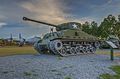
 Tanks on display at Ga. Veterans S.P.
 -
-
-

-

-

-
 155 mm Howitzer M1918A3 Schneider
 -
 Boeing B-29A, (B-29A-15-BN, AAF Ser. No. 42-93967) built in Marietta, GA


References[edit]
- ^ "Some Georgia parks moves to private management". OnlineAthens.com. Associated Press. May 27, 2013. Retrieved September 25, 2017.
External links[edit]
- Georgia Veterans State Park information
- Lake Blackshear Resort & Golf Club
- Sam Shortline
- Georgia Veterans Memorial State Park Camp Safety Patrol historical marker
31°57′23″N 83°54′58″W / 31.95639°N 83.91611°W
This Crisp County, Georgia state location article is a stub. You can help Wikipedia by expanding it. |
- Protected areas of Crisp County, Georgia
- State parks of Georgia (U.S. state)
- Military monuments and memorials in the United States
- Military and war museums in Georgia (U.S. state)
- Museums in Crisp County, Georgia
- Protected areas established in 1931
- 1931 establishments in Georgia (U.S. state)
- Georgia (U.S. state) geography stubs